AccuWeather


- Flood Warning
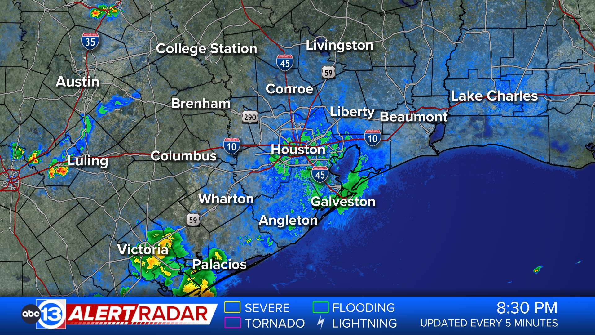
* WHAT...Flooding caused by excessive rainfall is expected. * WHERE...A portion of southeast Texas, including the following counties, Chambers, Harris and Liberty. * WHEN...Until 300 PM CDT. * IMPACTS...Flooding of rivers, creeks, streams, and other low-lying and flood-prone locations is imminent or occurring. Low-water crossings are inundated with water and may not be passable. * ADDITIONAL DETAILS... - At 1135 AM CDT, Doppler radar and automated rain gauges indicated heavy rain due to thunderstorms. Flooding is ongoing or expected to begin shortly in the warned area. Between 2 and 4 inches of rain have fallen. - Flooding impacts will continue, but no additional rainfall is expected. - Some locations that will experience flooding include... Eastern Baytown, Beach City, Mont Belvieu, Anahuac, Old River-Winfree, Cove, Devers, Wallisville and Hankamer. - This includes the following Low Water Crossings... Winfree Street at Smith Gully and Access Road at Turtle Bayou. - http://www.weather.gov/safety/floodMore
- Flash Flood Warning
FFWHGX The National Weather Service in League City has extended the * Flash Flood Warning for... Northwestern Liberty County in southeastern Texas... Central Montgomery County in southeastern Texas... Southwestern San Jacinto County in southeastern Texas... * Until 130 PM CDT. * At 1126 AM CDT, Doppler radar and automated rain gauges indicated thunderstorms producing heavy rain across the warned area. Between 2 and 5 inches of rain have fallen. Additional rainfall amounts of 1 to 2 inches are possible in the warned area. Flash flooding is ongoing or expected to begin shortly. HAZARD...Flash flooding caused by thunderstorms. SOURCE...Radar and automated gauges. IMPACT...Flash flooding of small creeks and streams, urban areas, highways, streets and underpasses as well as other poor drainage and low-lying areas. * Some locations that will experience flash flooding include... Conroe, Tomball, Cleveland, Willis, Pinehurst, The Woodlands, Shepherd, Panorama Village, Magnolia, Cut And Shoot, Montgomery, Stagecoach, North Cleveland and Lake Conroe Dam.More
- Flood Warning
* WHAT...Urban area and small stream flooding caused by excessive rainfall continues. * WHERE...A portion of southeast Texas, including the following counties, Chambers, Harris, Liberty and Montgomery. * WHEN...Until 600 PM CDT Friday. * IMPACTS...Flooding of rivers, creeks, streams, and other low-lying and flood-prone locations is imminent or occurring. Numerous roads remain closed due to flooding. Low-water crossings are inundated with water and may not be passable. Expect many areas of slow moving or standing water. It will take several hours for all the water from these storms to work through local drainage systems in urban areas. Local media have reported water rescues. * ADDITIONAL DETAILS... - At 1102 AM CDT, emergency management reported flooding in the warned area. Flooding is already occurring. Between 2 and 5 inches of rain have fallen today in addition to Thursday's rainfall. - Additional rainfall amounts of 0.5 to 1 inch are possible in the warned area. - Some locations that will experience flooding include... Southern Conroe, Humble, Tomball, Liberty, Dayton, Kingwood, Spring, Aldine, Greater Greenspoint, The Woodlands, Crosby, Oak Ridge North, Shenandoah, Splendora, Patton Village, Roman Forest, Woodbranch, Ames, Daisetta and Hardin. - http://www.weather.gov/safety/floodMore
- Flood Warning
...The Flood Warning is extended for the following rivers in Texas... East Fork San Jacinto at Cleveland affecting Harris, Montgomery, Liberty and San Jacinto Counties. East Fork San Jacinto near New Caney affecting Harris, Montgomery and Liberty Counties. Peach Creek at Splendora affecting Harris and Montgomery Counties. Caney Creek near Splendora affecting Harris and Montgomery Counties. West Fork San Jacinto near Conroe affecting Montgomery County. ...The Flood Warning continues for the following rivers in Texas... West Fork San Jacinto near Porter affecting Montgomery County. Lake Creek at Sendera Ranch Road affecting Montgomery County. San Jacinto River near Sheldon affecting Harris County. West Fork San Jacinto near Humble affecting Harris and Montgomery Counties. For the East Fork San Jacinto River...including Cleveland, New Caney...Major flooding is forecast. For the Peach Creek...including Splendora...Major flooding is forecast. For the West Fork San Jacinto River...including Porter, Sendera Ranch Road, Conroe, Humble, Sheldon...Major flooding is forecast. * WHAT...Major flooding is occurring and major flooding is forecast. * WHERE...Caney Creek near Splendora. * WHEN...Until tomorrow afternoon. * IMPACTS...At 21.0 feet, Major lowland flooding begins as Linda Lane begins to take on water. At 24.0 feet, FM 2090 begins to take on water. * ADDITIONAL DETAILS... - At 8:30 AM CDT Friday the stage was 23.2 feet. - Bankfull stage is 13.0 feet. - Recent Activity...The maximum river stage in the 24 hours ending at 8:30 AM CDT Friday was 26.0 feet. - Forecast...The river is expected to fall below flood stage late tonight and continue falling to 4.4 feet Wednesday morning. - Flood stage is 17.0 feet. - Flood History...This crest compares to a previous crest of 22.9 feet on 05/28/2016. - http://www.weather.gov/safety/floodMore
- Flood Warning
...The Flood Warning is extended for the following rivers in Texas... East Fork San Jacinto at Cleveland affecting Harris, Montgomery, Liberty and San Jacinto Counties. East Fork San Jacinto near New Caney affecting Harris, Montgomery and Liberty Counties. Peach Creek at Splendora affecting Harris and Montgomery Counties. Caney Creek near Splendora affecting Harris and Montgomery Counties. West Fork San Jacinto near Conroe affecting Montgomery County. ...The Flood Warning continues for the following rivers in Texas... West Fork San Jacinto near Porter affecting Montgomery County. Lake Creek at Sendera Ranch Road affecting Montgomery County. San Jacinto River near Sheldon affecting Harris County. West Fork San Jacinto near Humble affecting Harris and Montgomery Counties. For the East Fork San Jacinto River...including Cleveland, New Caney...Major flooding is forecast. For the Peach Creek...including Splendora...Major flooding is forecast. For the West Fork San Jacinto River...including Porter, Sendera Ranch Road, Conroe, Humble, Sheldon...Major flooding is forecast. * WHAT...Major flooding is occurring and major flooding is forecast. * WHERE...East Fork San Jacinto at Cleveland. * WHEN...Until early Sunday afternoon. * IMPACTS...At 23.0 feet, Sante Fe Railroad begins taking on water and the parking lot of the Best Western begins taking on water. At 25.0 feet, Lowest homes on Wells Road become threatened. * ADDITIONAL DETAILS... - At 8:30 AM CDT Friday the stage was 24.9 feet. - Bankfull stage is 13.0 feet. - Recent Activity...The maximum river stage in the 24 hours ending at 8:30 AM CDT Friday was 25.9 feet. - Forecast...The river is expected to fall below flood stage early Sunday morning and continue falling to 11.6 feet Wednesday morning. - Flood stage is 19.0 feet. - Flood History...This crest compares to a previous crest of 24.6 feet on 01/08/1998. - http://www.weather.gov/safety/floodMore
- Flood Warning
...The Flood Warning is extended for the following rivers in Texas... East Fork San Jacinto at Cleveland affecting Harris, Montgomery, Liberty and San Jacinto Counties. East Fork San Jacinto near New Caney affecting Harris, Montgomery and Liberty Counties. Peach Creek at Splendora affecting Harris and Montgomery Counties. Caney Creek near Splendora affecting Harris and Montgomery Counties. West Fork San Jacinto near Conroe affecting Montgomery County. ...The Flood Warning continues for the following rivers in Texas... West Fork San Jacinto near Porter affecting Montgomery County. Lake Creek at Sendera Ranch Road affecting Montgomery County. San Jacinto River near Sheldon affecting Harris County. West Fork San Jacinto near Humble affecting Harris and Montgomery Counties. For the East Fork San Jacinto River...including Cleveland, New Caney...Major flooding is forecast. For the Peach Creek...including Splendora...Major flooding is forecast. For the West Fork San Jacinto River...including Porter, Sendera Ranch Road, Conroe, Humble, Sheldon...Major flooding is forecast. * WHAT...Major flooding is occurring and major flooding is forecast. * WHERE...Peach Creek at Splendora. * WHEN...Until Sunday evening. * IMPACTS...At 20.0 feet, Intersection of US 59 and FM 2090 begins to flood. Intersection of Green Forest and East Twelve Oaks takes on water and cuts off homes. Homes on Buck Road become threatened. At 20.5 feet, Texas Vehicle Inspection Station becomes threatened. * ADDITIONAL DETAILS... - At 9:00 AM CDT Friday the stage was 20.4 feet. - Bankfull stage is 12.0 feet. - Recent Activity...The maximum river stage in the 24 hours ending at 9:00 AM CDT Friday was 20.4 feet. - Forecast...The river is expected to rise to a crest of 20.6 feet this afternoon. It will then fall below flood stage Sunday morning. - Flood stage is 14.0 feet. - Flood History...This crest compares to a previous crest of 20.7 feet on 05/26/1944. - http://www.weather.gov/safety/floodMore
- Flood Warning
...The Flood Warning is extended for the following rivers in Texas... East Fork San Jacinto at Cleveland affecting Harris, Montgomery, Liberty and San Jacinto Counties. East Fork San Jacinto near New Caney affecting Harris, Montgomery and Liberty Counties. Peach Creek at Splendora affecting Harris and Montgomery Counties. Caney Creek near Splendora affecting Harris and Montgomery Counties. West Fork San Jacinto near Conroe affecting Montgomery County. ...The Flood Warning continues for the following rivers in Texas... West Fork San Jacinto near Porter affecting Montgomery County. Lake Creek at Sendera Ranch Road affecting Montgomery County. San Jacinto River near Sheldon affecting Harris County. West Fork San Jacinto near Humble affecting Harris and Montgomery Counties. For the East Fork San Jacinto River...including Cleveland, New Caney...Major flooding is forecast. For the Peach Creek...including Splendora...Major flooding is forecast. For the West Fork San Jacinto River...including Porter, Sendera Ranch Road, Conroe, Humble, Sheldon...Major flooding is forecast. * WHAT...Major flooding is occurring and major flooding is forecast. * WHERE...West Fork San Jacinto near Conroe. * WHEN...Until late Sunday evening. * IMPACTS...At 117.8 feet, Major lowland flooding begins. * ADDITIONAL DETAILS... - At 9:15 AM CDT Friday the stage was 121.8 feet. - Bankfull stage is 113.8 feet. - Recent Activity...The maximum river stage in the 24 hours ending at 9:15 AM CDT Friday was 121.8 feet. - Forecast...The river is expected to rise to a crest of 122.1 feet this evening. It will then fall below flood stage late Sunday morning. - Flood stage is 115.8 feet. - Flood History...This crest compares to a previous crest of 121.8 feet on 06/27/1960. - http://www.weather.gov/safety/floodMore
- Flood Warning
...The Flood Warning is extended for the following rivers in Texas... East Fork San Jacinto at Cleveland affecting Harris, Montgomery, Liberty and San Jacinto Counties. East Fork San Jacinto near New Caney affecting Harris, Montgomery and Liberty Counties. Peach Creek at Splendora affecting Harris and Montgomery Counties. Caney Creek near Splendora affecting Harris and Montgomery Counties. West Fork San Jacinto near Conroe affecting Montgomery County. ...The Flood Warning continues for the following rivers in Texas... West Fork San Jacinto near Porter affecting Montgomery County. Lake Creek at Sendera Ranch Road affecting Montgomery County. San Jacinto River near Sheldon affecting Harris County. West Fork San Jacinto near Humble affecting Harris and Montgomery Counties. For the East Fork San Jacinto River...including Cleveland, New Caney...Major flooding is forecast. For the Peach Creek...including Splendora...Major flooding is forecast. For the West Fork San Jacinto River...including Porter, Sendera Ranch Road, Conroe, Humble, Sheldon...Major flooding is forecast. * WHAT...Minor flooding is occurring and moderate flooding is forecast. * WHERE...West Fork San Jacinto near Porter. * WHEN...Until early Monday morning. * IMPACTS...At 88.5 feet, Moderate lowland flooding begins. Lowest homes in Summer Hills subdivision along Firefly Lane and Butterfly Lane begin to flood. * ADDITIONAL DETAILS... - At 8:45 AM CDT Friday the stage was 84.0 feet. - Bankfull stage is 73.0 feet. - Recent Activity...The maximum river stage in the 24 hours ending at 8:45 AM CDT Friday was 84.0 feet. - Forecast...The river is expected to rise to a crest of 88.5 feet late tomorrow morning. It will then fall below flood stage early Sunday afternoon. - Flood stage is 81.0 feet. - Flood History...No available flood history. - http://www.weather.gov/safety/floodMore
- Flood Warning
...The Flood Warning is extended for the following rivers in Texas... East Fork San Jacinto at Cleveland affecting Harris, Montgomery, Liberty and San Jacinto Counties. East Fork San Jacinto near New Caney affecting Harris, Montgomery and Liberty Counties. Peach Creek at Splendora affecting Harris and Montgomery Counties. Caney Creek near Splendora affecting Harris and Montgomery Counties. West Fork San Jacinto near Conroe affecting Montgomery County. ...The Flood Warning continues for the following rivers in Texas... West Fork San Jacinto near Porter affecting Montgomery County. Lake Creek at Sendera Ranch Road affecting Montgomery County. San Jacinto River near Sheldon affecting Harris County. West Fork San Jacinto near Humble affecting Harris and Montgomery Counties. For the East Fork San Jacinto River...including Cleveland, New Caney...Major flooding is forecast. For the Peach Creek...including Splendora...Major flooding is forecast. For the West Fork San Jacinto River...including Porter, Sendera Ranch Road, Conroe, Humble, Sheldon...Major flooding is forecast. * WHAT...Moderate flooding is occurring and moderate flooding is forecast. * WHERE...Lake Creek at Sendera Ranch Road. * WHEN...Until early Monday morning. * ADDITIONAL DETAILS... - At 8:45 AM CDT Friday the stage was 144.1 feet. - Bankfull stage is 129.0 feet. - Recent Activity...The maximum river stage in the 24 hours ending at 8:45 AM CDT Friday was 144.1 feet. - Forecast...The river is expected to rise to a crest of 144.0 feet this afternoon. It will then fall below flood stage Sunday afternoon. - Flood stage is 138.0 feet. - Flood History...This crest compares to a previous crest of 142.1 feet on 04/19/2016. - http://www.weather.gov/safety/floodMore
- Flood Warning
...The Flood Warning is extended for the following rivers in Texas... East Fork San Jacinto at Cleveland affecting Harris, Montgomery, Liberty and San Jacinto Counties. East Fork San Jacinto near New Caney affecting Harris, Montgomery and Liberty Counties. Peach Creek at Splendora affecting Harris and Montgomery Counties. Caney Creek near Splendora affecting Harris and Montgomery Counties. West Fork San Jacinto near Conroe affecting Montgomery County. ...The Flood Warning continues for the following rivers in Texas... West Fork San Jacinto near Porter affecting Montgomery County. Lake Creek at Sendera Ranch Road affecting Montgomery County. San Jacinto River near Sheldon affecting Harris County. West Fork San Jacinto near Humble affecting Harris and Montgomery Counties. For the East Fork San Jacinto River...including Cleveland, New Caney...Major flooding is forecast. For the Peach Creek...including Splendora...Major flooding is forecast. For the West Fork San Jacinto River...including Porter, Sendera Ranch Road, Conroe, Humble, Sheldon...Major flooding is forecast. * WHAT...Major flooding is occurring and major flooding is forecast. * WHERE...East Fork San Jacinto near New Caney. * WHEN...Until early Wednesday morning. * IMPACTS...At 69.0 feet, Major lowland flooding begins as several homes become inundated. * ADDITIONAL DETAILS... - At 9:16 AM CDT Friday the stage was 69.6 feet. - Bankfull stage is 54.5 feet. - Recent Activity...The maximum river stage in the 24 hours ending at 9:16 AM CDT Friday was 69.6 feet. - Forecast...The river is expected to rise to a crest of 78.0 feet late this evening. It will then fall below flood stage early Tuesday afternoon. - Flood stage is 58.0 feet. - Flood History...This crest compares to a previous crest of 76.0 feet on 10/19/1994. - http://www.weather.gov/safety/floodMore
- Flood Warning
...The Flood Warning is extended for the following rivers in Texas... East Fork San Jacinto at Cleveland affecting Harris, Montgomery, Liberty and San Jacinto Counties. East Fork San Jacinto near New Caney affecting Harris, Montgomery and Liberty Counties. Peach Creek at Splendora affecting Harris and Montgomery Counties. Caney Creek near Splendora affecting Harris and Montgomery Counties. West Fork San Jacinto near Conroe affecting Montgomery County. ...The Flood Warning continues for the following rivers in Texas... West Fork San Jacinto near Porter affecting Montgomery County. Lake Creek at Sendera Ranch Road affecting Montgomery County. San Jacinto River near Sheldon affecting Harris County. West Fork San Jacinto near Humble affecting Harris and Montgomery Counties. For the East Fork San Jacinto River...including Cleveland, New Caney...Major flooding is forecast. For the Peach Creek...including Splendora...Major flooding is forecast. For the West Fork San Jacinto River...including Porter, Sendera Ranch Road, Conroe, Humble, Sheldon...Major flooding is forecast. * WHAT...Major flooding is occurring and major flooding is forecast. * WHERE...West Fork San Jacinto near Humble. * WHEN...Until further notice. * IMPACTS...At 55.2 feet, Major lowland flooding continues with up to 6 inches of water is over the 800 block Hamblen Road adjacent to the Kingwood Cove Country Club Golf Course with many homes in the Bellau Woods and Treasure Cove subdivision are flooded. * ADDITIONAL DETAILS... - At 8:45 AM CDT Friday the stage was 54.4 feet. - Bankfull stage is 15.0 feet. - Recent Activity...The maximum river stage in the 24 hours ending at 8:45 AM CDT Friday was 54.4 feet. - Forecast...The river is expected to rise to a crest of 61.0 feet early Sunday morning. It will then fall below flood stage late Tuesday evening. - Flood stage is 49.3 feet. - Flood History...This crest compares to a previous crest of 60.1 feet on 11/15/1998. - http://www.weather.gov/safety/floodMore
- Flood Warning
...The Flood Warning is extended for the following rivers in Texas... East Fork San Jacinto at Cleveland affecting Harris, Montgomery, Liberty and San Jacinto Counties. East Fork San Jacinto near New Caney affecting Harris, Montgomery and Liberty Counties. Peach Creek at Splendora affecting Harris and Montgomery Counties. Caney Creek near Splendora affecting Harris and Montgomery Counties. West Fork San Jacinto near Conroe affecting Montgomery County. ...The Flood Warning continues for the following rivers in Texas... West Fork San Jacinto near Porter affecting Montgomery County. Lake Creek at Sendera Ranch Road affecting Montgomery County. San Jacinto River near Sheldon affecting Harris County. West Fork San Jacinto near Humble affecting Harris and Montgomery Counties. For the East Fork San Jacinto River...including Cleveland, New Caney...Major flooding is forecast. For the Peach Creek...including Splendora...Major flooding is forecast. For the West Fork San Jacinto River...including Porter, Sendera Ranch Road, Conroe, Humble, Sheldon...Major flooding is forecast. * WHAT...Moderate flooding is occurring and major flooding is forecast. * WHERE...San Jacinto River near Sheldon. * WHEN...Until further notice. * IMPACTS...At 15.0 feet, Major lowland flooding begins. * ADDITIONAL DETAILS... - At 9:15 AM CDT Friday the stage was 14.8 feet. - Bankfull stage is 8.0 feet. - Recent Activity...The maximum river stage in the 24 hours ending at 9:15 AM CDT Friday was 14.8 feet. - Forecast...The river is expected to rise to a crest of 19.1 feet late Sunday morning. - Flood stage is 10.0 feet. - Flood History...This crest compares to a previous crest of 19.3 feet on 04/06/1979. - http://www.weather.gov/safety/floodMore
- Flood Warning
...The Flood Warning is extended for the following rivers in Texas... Menard Creek near Rye affecting Hardin, Liberty and Polk Counties. Bedias Creek near Madisonville affecting Walker and Madison Counties. ...The Flood Warning continues for the following rivers in Texas... Trinity River near Romayor affecting Polk, Liberty and San Jacinto Counties. Trinity River at Liberty affecting Liberty County. Trinity River near Goodrich affecting Polk, Liberty and San Jacinto Counties. Trinity River near Moss Bluff affecting Liberty and Chambers Counties. Trinity River at Riverside affecting Walker, Polk, San Jacinto and Trinity Counties. For the Trinity River...including Riverside, Romayor, Goodrich, Liberty, Moss Bluff...Major flooding is forecast. For the Menard Creek...including Rye...Major flooding is forecast. * WHAT...Major flooding is occurring and major flooding is forecast. This approaches the flood of record. * WHERE...Trinity River at Liberty. * WHEN...Until further notice. * IMPACTS...At 29.0 feet, Major lowland flooding begins as homes in several subdivisions above Liberty begin flooding. Extensive flooding over much of Liberty County can be expected with each incremental rise in the river. * ADDITIONAL DETAILS... - At 8:15 AM CDT Friday the stage was 30.7 feet. - Bankfull stage is 21.0 feet. - Recent Activity...The maximum river stage in the 24 hours ending at 8:15 AM CDT Friday was 30.7 feet. - Forecast...The river is expected to rise to 31.7 feet early Sunday afternoon. Additional rises are possible thereafter. - Flood stage is 26.0 feet. - Flood History...This crest compares to a previous crest of 31.0 feet on 10/21/1994. - http://www.weather.gov/safety/floodMore
- Flood Warning
...The Flood Warning is extended for the following rivers in Texas... Menard Creek near Rye affecting Hardin, Liberty and Polk Counties. Bedias Creek near Madisonville affecting Walker and Madison Counties. ...The Flood Warning continues for the following rivers in Texas... Trinity River near Romayor affecting Polk, Liberty and San Jacinto Counties. Trinity River at Liberty affecting Liberty County. Trinity River near Goodrich affecting Polk, Liberty and San Jacinto Counties. Trinity River near Moss Bluff affecting Liberty and Chambers Counties. Trinity River at Riverside affecting Walker, Polk, San Jacinto and Trinity Counties. For the Trinity River...including Riverside, Romayor, Goodrich, Liberty, Moss Bluff...Major flooding is forecast. For the Menard Creek...including Rye...Major flooding is forecast. * WHAT...Minor flooding is occurring and major flooding is forecast. This approaches the flood of record. * WHERE...Trinity River near Romayor. * WHEN...Until further notice. * IMPACTS...At 42.8 feet, There is massive lowland flooding in vicinity of gage with thousands of head of livestock endangered unless moved to higher ground. * ADDITIONAL DETAILS... - At 8:30 AM CDT Friday the stage was 40.7 feet. - Bankfull stage is 30.0 feet. - Recent Activity...The maximum river stage in the 24 hours ending at 8:30 AM CDT Friday was 41.0 feet. - Forecast...The river is expected to rise to a crest of 44.4 feet tomorrow evening. - Flood stage is 40.0 feet. - Flood History...This crest compares to a previous crest of 43.5 feet on 04/13/1945. - http://www.weather.gov/safety/floodMore
- Flood Warning
...The Flood Warning is extended for the following rivers in Texas... Menard Creek near Rye affecting Hardin, Liberty and Polk Counties. Bedias Creek near Madisonville affecting Walker and Madison Counties. ...The Flood Warning continues for the following rivers in Texas... Trinity River near Romayor affecting Polk, Liberty and San Jacinto Counties. Trinity River at Liberty affecting Liberty County. Trinity River near Goodrich affecting Polk, Liberty and San Jacinto Counties. Trinity River near Moss Bluff affecting Liberty and Chambers Counties. Trinity River at Riverside affecting Walker, Polk, San Jacinto and Trinity Counties. For the Trinity River...including Riverside, Romayor, Goodrich, Liberty, Moss Bluff...Major flooding is forecast. For the Menard Creek...including Rye...Major flooding is forecast. * WHAT...Moderate flooding is occurring and major flooding is forecast. * WHERE...Trinity River near Moss Bluff. * WHEN...Until further notice. * IMPACTS...At 17.2 feet, Major lowland flooding begins in the vicinity of the gage. * ADDITIONAL DETAILS... - At 8:30 AM CDT Friday the stage was 15.5 feet. - Bankfull stage is 9.2 feet. - Recent Activity...The maximum river stage in the 24 hours ending at 8:30 AM CDT Friday was 15.6 feet. - Forecast...The river is expected to rise to 17.5 feet Tuesday morning. Additional rises are possible thereafter. - Flood stage is 12.2 feet. - Flood History...This crest compares to a previous crest of 18.7 feet on 09/01/2017. - http://www.weather.gov/safety/floodMore
- Flood Warning
...The Flood Warning is extended for the following rivers in Texas... Menard Creek near Rye affecting Hardin, Liberty and Polk Counties. Bedias Creek near Madisonville affecting Walker and Madison Counties. ...The Flood Warning continues for the following rivers in Texas... Trinity River near Romayor affecting Polk, Liberty and San Jacinto Counties. Trinity River at Liberty affecting Liberty County. Trinity River near Goodrich affecting Polk, Liberty and San Jacinto Counties. Trinity River near Moss Bluff affecting Liberty and Chambers Counties. Trinity River at Riverside affecting Walker, Polk, San Jacinto and Trinity Counties. For the Trinity River...including Riverside, Romayor, Goodrich, Liberty, Moss Bluff...Major flooding is forecast. For the Menard Creek...including Rye...Major flooding is forecast. * WHAT...Major flooding is occurring and major flooding is forecast. * WHERE...Trinity River near Goodrich. * WHEN...Until further notice. * IMPACTS...At 46.8 feet, In past flood at levels above 46.8 feet many homes below Lake Livingston were flooded...some with water midway up their windows. * ADDITIONAL DETAILS... - At 7:45 AM CDT Friday the stage was 48.4 feet. - Bankfull stage is 36.0 feet. - Recent Activity...The maximum river stage in the 24 hours ending at 7:45 AM CDT Friday was 48.4 feet. - Forecast...The river is expected to rise to a crest of 49.2 feet this evening. - Flood stage is 36.0 feet. - Flood History...This crest compares to a previous crest of 49.0 feet on 10/18/1994. - http://www.weather.gov/safety/floodMore
- Flood Watch
* WHAT...Flooding caused by excessive rainfall continues to be possible. * WHERE...A portion of southeast Texas, including the following areas, Brazos, Burleson, Coastal Harris, Grimes, Houston, Inland Harris, Madison, Montgomery, Northern Liberty, Polk, San Jacinto, Southern Liberty, Trinity, Walker, Waller and Washington. * WHEN...Until 7 PM CDT this evening. * IMPACTS...Excessive runoff may result in flooding of rivers, creeks, streams, and other low-lying and flood-prone locations. Flooding may occur in poor drainage and urban areas. Low-water crossings may be flooded. * ADDITIONAL DETAILS... - Model guidance suggests potential for heavier rains in the watch area early today through this evening. Any further rainfall would at best slow the recession of existing floodwaters, and at worst would aggravate this flooding. Saturated soils will result in a greater risk of flash flooding, even at rain rates that typically do not cause problems in this area. 1-2 inches of new rainfall are possible with isolated totals of up to 3-5 inches. - http://www.weather.gov/safety/floodMore
- Flood Watch
* WHAT...Flooding caused by excessive rainfall continues to be possible. * WHERE...A portion of southeast Texas, including the following county, Chambers. * WHEN...Until 7 PM CDT this evening. * IMPACTS...Excessive runoff may result in flooding of rivers, creeks, streams, and other low-lying and flood-prone locations. Flooding may occur in poor drainage and urban areas. Low-water crossings may be flooded. * ADDITIONAL DETAILS... - Model guidance suggests potential for heavier rains in the watch area early today through this evening. Any further rainfall would at best slow the recession of existing floodwaters, and at worst would aggravate this flooding. Saturated soils will result in a greater risk of flash flooding, even at rain rates that typically do not cause problems in this area. 1-2 inches of new rainfall are possible with isolated totals of up to 3-5 inches. - http://www.weather.gov/safety/floodMore