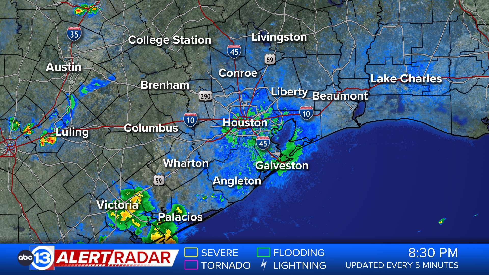
ABC13 Houston Weather Radar for Southeast Texas

- Flood Warning
* WHAT...Urban area and small stream flooding caused by excessive rainfall continues. * WHERE...A portion of southeast Texas, including the following counties, Brazoria, Galveston and Harris. * WHEN...Until 815 PM CDT. * IMPACTS...Flooding of rivers, creeks, streams, and other low-lying and flood-prone locations is imminent or occurring. Expect many areas of slow moving or standing water. * ADDITIONAL DETAILS... - At 321 PM CDT, Doppler radar and automated rain gauges indicated heavy rain due to thunderstorms from this morning. Flooding is already occurring in the warned area. Between 3 and 7 inches of rain have fallen. - Some roadways still closed due to water including low water crossings along State Highway 146 near FM 517 and along State Highway 275 on Galveston Island. Multiple creeks remain out of their banks as well including Cloud Bayou, Willow Bayou, Old Chigger Creek, and Magnolia Bayou in portions of Galveston County. - Some locations that will experience flooding include... Southern Pasadena, southeastern Pearland, League City, Galveston Causeway, Galveston Island West End, Texas City, Friendswood, Alvin, Dickinson, La Marque, Santa Fe, southwestern Seabrook, Webster, Hitchcock, Kemah, southern Clear Lake, Galveston Pier 21, Nassau Bay, Taylor Lake Village and El Lago. - http://www.weather.gov/safety/floodMore
- Flood Warning
...The Flood Warning continues for the following rivers in Texas... Trinity River at Riverside affecting Walker, San Jacinto, Polk and Trinity Counties. East Fork San Jacinto near New Caney affecting Harris, Montgomery and Liberty Counties. ...The Flood Warning is extended for the following rivers in Texas... Long King Creek near Livingston affecting San Jacinto and Polk Counties. San Bernard River near Sweeny affecting Brazoria County. Tres Palacios River near Midfield affecting Matagorda and Wharton Counties. For the Trinity River...including Riverside...Minor flooding is forecast. For the Long King Creek...including Livingston...Minor flooding is forecast. For the East Fork San Jacinto River...including New Caney...Moderate flooding is forecast. For the San Bernard River...including Sweeny, Boling...Minor flooding is forecast. * WHAT...Minor flooding is occurring and minor flooding is forecast. * WHERE...Long King Creek near Livingston. * WHEN...Until late tomorrow morning. * IMPACTS...At 19.0 feet, At levels above 19 feet minor lowland flooding begins as water escapes the main channel of the creek. * ADDITIONAL DETAILS... - At 2:46 PM CDT Friday the stage was 21.3 feet. - Bankfull stage is 14.0 feet. - Recent Activity...The maximum river stage in the 24 hours ending at 2:46 PM CDT Friday was 21.3 feet. - Forecast...The river is expected to fall below flood stage late this evening and continue falling to 3.3 feet early Wednesday afternoon. - Flood stage is 19.0 feet. - Flood History...This crest compares to a previous crest of 21.1 feet on 06/26/1999. - http://www.weather.gov/safety/floodMore
- Flood Warning
...The Flood Warning continues for the following rivers in Texas... Trinity River at Riverside affecting Walker, San Jacinto, Polk and Trinity Counties. East Fork San Jacinto near New Caney affecting Harris, Montgomery and Liberty Counties. ...The Flood Warning is extended for the following rivers in Texas... Long King Creek near Livingston affecting San Jacinto and Polk Counties. San Bernard River near Sweeny affecting Brazoria County. Tres Palacios River near Midfield affecting Matagorda and Wharton Counties. For the Trinity River...including Riverside...Minor flooding is forecast. For the Long King Creek...including Livingston...Minor flooding is forecast. For the East Fork San Jacinto River...including New Caney...Moderate flooding is forecast. For the San Bernard River...including Sweeny, Boling...Minor flooding is forecast. * WHAT...Moderate flooding is occurring and moderate flooding is forecast. * WHERE...East Fork San Jacinto near New Caney. * WHEN...Until further notice. * IMPACTS...At 68.5 feet, Moderate lowland flooding continues with water over the lowest slab elevations of buildings on the downstream side near the gauge, as well as several hunting camps along the left bank approximately 2 miles downstream of the gauge begin to take on water. Widespread flooding continues in the vicinity of the gauge and in the right floodplain with many roads including FM 1485 inundated and closed. * ADDITIONAL DETAILS... - At 2:00 PM CDT Friday the stage was 67.2 feet. - Bankfull stage is 54.5 feet. - Recent Activity...The maximum river stage in the 24 hours ending at 2:00 PM CDT Friday was 67.2 feet. - Forecast...The river is expected to rise to a crest of 67.2 feet late this afternoon. - Flood stage is 58.0 feet. - Flood History...This crest compares to a previous crest of 67.7 feet on 05/19/1989. - http://www.weather.gov/safety/floodMore
- Flood Watch
* WHAT...Flooding caused by excessive rainfall continues to be possible. * WHERE...Portions of southeast and coastal Texas, including the following areas, Coastal Jackson and Inland Jackson. In southeast Texas, Bolivar Peninsula, Brazoria Islands, Chambers, Coastal Brazoria, Coastal Galveston, Coastal Harris, Coastal Matagorda, Fort Bend, Galveston Island, Inland Brazoria, Inland Galveston, Inland Harris, Inland Matagorda, Matagorda Islands, Northern Liberty, Southern Liberty and Wharton. * WHEN...Through Saturday afternoon. * IMPACTS...Excessive runoff may result in flooding of rivers, creeks, streams, and other low-lying and flood-prone locations. Flooding may occur in poor drainage and urban areas. Storm drains and ditches may become clogged with debris. * ADDITIONAL DETAILS... - Another round of moderate to heavy showers and thunderstorms is possible overnight tonight into Saturday morning. Additional rainfall over wet soils may lead to flooding. - http://www.weather.gov/safety/floodMore
- Flood Watch
* WHAT...Flooding caused by excessive rainfall continues to be possible. * WHERE...A portion of south Texas, including the following areas, Aransas Islands, Calhoun Islands, Coastal Aransas, Coastal Calhoun, Coastal Refugio, Inland Calhoun, Inland Refugio and Victoria. * WHEN...Through Saturday evening. * IMPACTS...Excessive runoff may result in flooding of rivers, creeks, streams, and other low-lying and flood-prone locations. Flooding may occur in poor drainage and urban areas. * ADDITIONAL DETAILS... - Excessive Rainfall - http://www.weather.gov/safety/floodMore


