loader

ACCUWEATHER FORECAST
Stormy weather continues this week, potentially affecting already hard-hit places
The stormy weather continues through the end of the week. The ABC13 Weather Team has a look at the biggest threats.

Weather Maps
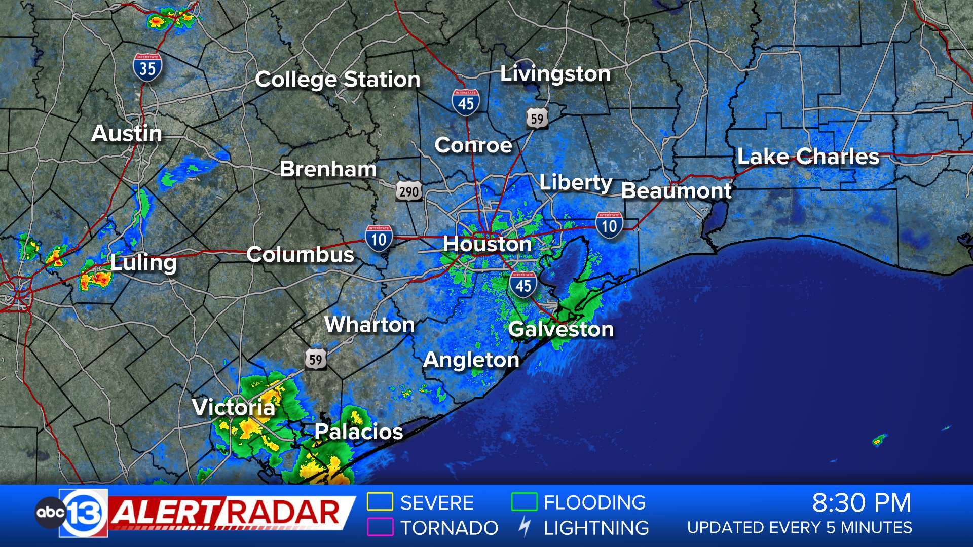
ABC13 Houston Weather Radar for Southeast Texas
Show More

Weather News
Show More

Travel Planner


  • Flood Warning

    ...The Flood Warning is extended for the following rivers in Texas... Trinity River near Romayor affecting San Jacinto, Polk and Liberty Counties. ...The Flood Warning continues for the following rivers in Texas... Trinity River at Liberty affecting Liberty County. Trinity River near Goodrich affecting San Jacinto, Polk and Liberty Counties. Menard Creek near Rye affecting Hardin, Polk and Liberty Counties. For the Trinity River...including Romayor, Goodrich, Liberty, Moss Bluff...Major flooding is forecast. For the Menard Creek...including Rye...Major flooding is forecast. * WHAT...Major flooding is forecast. * WHERE...Trinity River near Romayor. * WHEN...From this afternoon until further notice. * IMPACTS...At 42.8 feet, There is massive lowland flooding in vicinity of the gage with thousands of head of livestock endangered unless moved to higher ground. * ADDITIONAL DETAILS... - At 11:30 AM CDT Thursday the stage was 38.7 feet. - Bankfull stage is 30.0 feet. - Forecast...The river is expected to rise above flood stage late this afternoon and continue rising to a crest of 45.9 feet early tomorrow afternoon. - Flood stage is 40.0 feet. - Flood History...No available flood history. - http://www.weather.gov/safety/floodMore

  • Flood Warning

    ...The Flood Warning is extended for the following rivers in Texas... Trinity River near Romayor affecting San Jacinto, Polk and Liberty Counties. ...The Flood Warning continues for the following rivers in Texas... Trinity River at Liberty affecting Liberty County. Trinity River near Goodrich affecting San Jacinto, Polk and Liberty Counties. Menard Creek near Rye affecting Hardin, Polk and Liberty Counties. For the Trinity River...including Romayor, Goodrich, Liberty, Moss Bluff...Major flooding is forecast. For the Menard Creek...including Rye...Major flooding is forecast. * WHAT...Major flooding is occurring and major flooding is forecast. This approaches the flood of record. * WHERE...Trinity River at Liberty. * WHEN...Until further notice. * IMPACTS...At 29.0 feet, Major lowland flooding begins as homes in several subdivisions above Liberty begin flooding. Extensive flooding over much of Liberty County can be expected with each incremental rise in the river. * ADDITIONAL DETAILS... - At 12:15 PM CDT Thursday the stage was 30.3 feet. - Bankfull stage is 21.0 feet. - Recent Activity...The maximum river stage in the 24 hours ending at 12:15 PM CDT Thursday was 30.3 feet. - Forecast...The river is expected to rise to a crest of 32.0 feet early Sunday afternoon. - Flood stage is 26.0 feet. - Flood History...This crest compares to a previous crest of 32.7 feet on 09/01/2017. - http://www.weather.gov/safety/floodMore

  • Flood Warning

    ...The Flood Warning is extended for the following rivers in Texas... Trinity River near Romayor affecting San Jacinto, Polk and Liberty Counties. ...The Flood Warning continues for the following rivers in Texas... Trinity River at Liberty affecting Liberty County. Trinity River near Goodrich affecting San Jacinto, Polk and Liberty Counties. Menard Creek near Rye affecting Hardin, Polk and Liberty Counties. For the Trinity River...including Romayor, Goodrich, Liberty, Moss Bluff...Major flooding is forecast. For the Menard Creek...including Rye...Major flooding is forecast. * WHAT...Major flooding is occurring and major flooding is forecast. * WHERE...Trinity River near Goodrich. * WHEN...Until further notice. * IMPACTS...At 46.8 feet, In past flood at levels above 46.8 feet many homes below Lake Livingston were flooded...some with water midway up their windows. * ADDITIONAL DETAILS... - At 11:45 AM CDT Thursday the stage was 43.6 feet. - Bankfull stage is 36.0 feet. - Recent Activity...The maximum river stage in the 24 hours ending at 11:45 AM CDT Thursday was 43.6 feet. - Forecast...The river is expected to rise to a crest of 48.2 feet tomorrow morning. - Flood stage is 36.0 feet. - Flood History...This crest compares to a previous crest of 48.3 feet on 08/30/2017. - http://www.weather.gov/safety/floodMore

  • Flood Warning

    ...Forecast flooding changed from Moderate to Major severity for the following rivers in Texas... Trinity River near Moss Bluff affecting Chambers and Liberty Counties. For the Trinity River...including Romayor, Goodrich, Liberty, Moss Bluff...Major flooding is forecast. * WHAT...Minor flooding is occurring and major flooding is forecast. This approaches the flood of record. * WHERE...Trinity River near Moss Bluff. * WHEN...Until further notice. * IMPACTS...At 17.2 feet, Major lowland flooding begins in the vicinity of the gage. * ADDITIONAL DETAILS... - At 11:30 AM CDT Thursday the stage was 14.7 feet. - Bankfull stage is 9.2 feet. - Recent Activity...The maximum river stage in the 24 hours ending at 11:30 AM CDT Thursday was 14.7 feet. - Forecast...The river is expected to rise to 18.0 feet Tuesday morning. Additional rises are possible thereafter. - Flood stage is 12.2 feet. - Flood History...This crest compares to a previous crest of 18.7 feet on 09/01/2017. - http://www.weather.gov/safety/floodMore

  • Flash Flood Warning

    FFWHGX The National Weather Service in League City has extended the * Flash Flood Warning for... Southeastern Grimes County in southeastern Texas... Western Montgomery County in southeastern Texas... South Central Walker County in southeastern Texas... Northeastern Waller County in southeastern Texas... * Until 130 PM CDT. * At 1155 AM CDT, Doppler radar and automated rain gauges indicated thunderstorms producing heavy rain across the warned area. Between 4 and 8 inches of rain have fallen. Additional rainfall amounts of 0.5 to 1.5 inches are possible in the warned area. Flash flooding is ongoing or expected to begin shortly. HAZARD...Flash flooding caused by thunderstorms. SOURCE...Radar and automated gauges. IMPACT...Flash flooding of small creeks and streams, urban areas, highways, streets and underpasses as well as other poor drainage and low-lying areas. * Some locations that will experience flash flooding include... Conroe, Willis, Pinehurst, The Woodlands, Panorama Village, Magnolia, Cut And Shoot, New Waverly, Montgomery, Stagecoach, Todd Mission, Lake Conroe Dam, Dobbin, Dacus, Plantersville and Richards. This includes the following Low Water Crossings... County Road 202 at Hurricane Creek, Farm to Market 2854 at Alligator Creek, W Dallas and W Lewis Streets at Alligator Creek, State Highway 105 at Caney Creek, Mary Wagner Road at Hostetter Creek, Dacus Johnson Road at Lake Creek, Honea Egypt Road at Lake Creek, State Highway 105 Old Dobbin Road at Lake Creek, Superior Road at Lake Creek, Farm to Market 149 at Little Lake Creek, Walden Road at Stewarts Creek, E Dallas Street at Stewarts Creek, State Highway 105 near East Davis Street, Calvary Road at Weirs Creek, North Pacific Street at Alligator Creek, North Thompson Street at Alligator Creek, North Woody Creek Drive at Alligator Creek, West Semands Avenue at Alligator Creek West Fork, Holly Drive at Alligator Creek West Branch, Mockingbird Hill at Crystal Creek East Fork, Rolling Hills at Crystal Creek Tributary Four, Oak Valley Lane at Decker Branch, Pin Oak St and Honea Eygpt Road, Mount Moriah Road at Little Caney Creek, Big Oak Drive at Little Lake Creek Tributary, Forest Woods Lane at Little Lake Creek Tributary, Anderson Road at Live Branch, Little Thorn Lane and nearby lowlying streets, Pine Bark Trail and Cole Valley Drive, Honea Egypt Road at Mound Creek, Buck Ridge Road at Mound Creek Tributary, Tejas Boulevard at Rush Creek Tributary, Marilyn Street at Silverdale Creek, Avenue E at Possum Branch, Webb and College Streets along Possum Branch, Memorial Lane at White Oak Creek North, Joseph Road at Walnut Creek, Interstate 45 at Loop 336 South, Lakeside and Hillside Drives at Martin Creek, Conroe Drive at Alligator Creek, Pine Shadows Drive at Alligator Creek, South Woody Creek Drive at Alligator Creek, Pinebark Lane at Crystal Creek Tributary Four, Bluewater Road at Little Lake Creek Tributary, Brown Cone Lane at Mill Creek Tributary, Pine Needle Lane at Mill Creek Tributary, Cole Vallye Drive at Mill Creek Tributary, Avenue F at Possum Branch, East Phillips Street at Possum Branch, Pine Bark along Mill Creek Tributary 1, Gossamer Lane at Mill Creek Tributary, College St at Possum Branch and Honea Eygpt Road at Lake Creek Tributary.More

  • Flash Flood Warning

    FFWHGX The National Weather Service in League City has extended the * Flash Flood Warning for... Harris County in southeastern Texas... Southern Liberty County in southeastern Texas... South Central Montgomery County in southeastern Texas... * Until 200 PM CDT. * At 1139 AM CDT, Doppler radar and automated rain gauges indicated thunderstorms producing heavy rain in Water rescues ongoing in Kingwood. Between 4 and 7 inches of rain have fallen. Additional rainfall amounts of 1 to 2 inches are possible in the warned area. Flash flooding is already occurring. HAZARD...Life threatening flash flooding. Thunderstorms producing flash flooding. SOURCE...Radar and automated gauges. IMPACT...Life threatening flash flooding of creeks and streams, urban areas, highways, streets and underpasses. * Some locations that will experience flash flooding include... Humble, Tomball, Liberty, Dayton, Kingwood, Spring, Aldine, Greater Greenspoint, The Woodlands, Oak Ridge North, Shenandoah, Ames, Daisetta, Hardin, Kenefick, Devers, Lake Houston, Atascocita, Bush Intercontinental Airport and Hurricane Harbor Splashtown. This includes the following Low Water Crossings... Zion Road at Boggs Gully, Hardy Toll Road and Rankin Road, Farm to Market 2978 at Willow Creek, Gosling Road at Willow Creek, Valka Road at Theiss Gully, Lawrence Street at Cancer Center, Walden Way at Willow Creek, Beaumont Street at Abbott Creek Tributary, Texas Street at Big Bayou Branch, Clennie Needham Rd at Bens Branch Tributary One, Beltway 8 at JFK, Beltway 8 at Hardy Toll Road, Interstate 45 at 1960, Interstate 45 at Beltway 8 North, Interstate 45 at Greens, US 59 at Beltway 8 North, US 59 at Will Clayton Pkwy, Mills Branch Dr near Ford Rd, Rustling Elms Drive, Driveway (Meadow Brook), Azalea Way, Shimmering Pines Road and Layl Drive at Abbott Creek.More

  • Flood Warning

    ...The National Weather Service in Houston/Galveston TX has issued a Flood Warning for the following rivers in Texas... Spring Creek near Spring affecting Harris and Montgomery Counties. For the Spring Creek...including Spring...Minor flooding is forecast. * WHAT...Minor flooding is forecast. * WHERE...Spring Creek near Spring. * WHEN...Until late tonight. * IMPACTS...At 92.5 feet, Minor lowland flooding contiues with the north side of I-45 turnaround beginning to take on water. * ADDITIONAL DETAILS... - At 10:45 AM CDT Thursday the stage was 87.9 feet. - Bankfull stage is 87.1 feet. - Forecast...The river is expected to rise above flood stage this afternoon to a crest of 93.0 feet late this afternoon. It will then fall below flood stage late this afternoon. - Flood stage is 91.5 feet. - Flood History...No available flood history. - http://www.weather.gov/safety/floodMore

  • Flood Warning

    ...The National Weather Service in Houston/Galveston TX has issued a Flood Warning for the following rivers in Texas... Willow Creek near Tomball affecting Harris County. For the Willow Creek...including Tomball, Tomball...Minor flooding is forecast. * WHAT...Minor flooding is expected. * WHERE...Willow Creek near Tomball. * WHEN...From this morning until further notice. * ADDITIONAL DETAILS... - At 9:45 AM CDT Thursday the stage was 123.2 feet. - Bankfull stage is 126.4 feet. - Forecast...The river is expected to rise to continue to rise throughout the day into flood stage. - Flood stage is 129.4 feet. - Flood History...This crest compares to a previous crest of 127.0 feet on 10/31/2015. - http://www.weather.gov/safety/floodMore

  • Flood Warning

    ...The National Weather Service in Houston/Galveston TX has issued a Flood Warning for the following rivers in Texas... Willow Creek Near Tomball affecting Harris County. For the Willow Creek...including Tomball, Tomball...Minor flooding is forecast. * WHAT...Minor flooding is forecast. * WHERE...Willow Creek near Tomball. * WHEN...From this morning until further notice. * ADDITIONAL DETAILS... - At 10:35 AM CDT Thursday the stage was 152.0 feet. - Bankfull stage is 0.0 feet. - Forecast...The river is expected to rise above flood stage this afternoon and continue rising to 156.5 feet this afternoon. Additional rises are possible thereafter. - Flood stage is 155.7 feet. - Flood History...This crest compares to a previous crest of 156.6 feet on 11/26/1985. - http://www.weather.gov/safety/floodMore

  • Flood Warning

    ...The Flood Warning is extended for the following rivers in Texas... West Fork San Jacinto near Humble affecting Harris and Montgomery Counties. For the West Fork San Jacinto River...including Humble...Major flooding is forecast. * WHAT...Major flooding is forecast. * WHERE...West Fork San Jacinto near Humble. * WHEN...From this afternoon until further notice. * IMPACTS...At 52.3 feet, Major lowland flooding begins as homes on Lake Lane West and Southshore Drive in the Belleau Woods subdivision begin flooding. Roads into the Treasure Cove subdivision are inundated and homes along Aqua Vista Drive threatened. Water is in many homes on Lake Point Drive in the Northshore subdivision. At 55.2 feet, Major lowland flooding continues with up to 6 inches of water is over the 800 block Hamblen Road adjacent to the Kingwood Cove Country Club Golf Course with many homes in the Bellau Woods and Treasure Cove subdivision are flooded. * ADDITIONAL DETAILS... - At 9:45 AM CDT Thursday the stage was 48.2 feet. - Bankfull stage is 45.3 feet. - Forecast...The river is expected to rise above flood stage this afternoon and continue rising to a crest of 61.1 feet late Saturday evening. - Flood stage is 49.3 feet. - Flood History...This crest compares to a previous crest of 62.0 feet on 05/29/2016. - http://www.weather.gov/safety/floodMore

  • Flash Flood Warning

    FFWHGX The National Weather Service in League City has extended the * Flash Flood Warning for... Harris County in southeastern Texas... Northwestern Liberty County in southeastern Texas... Southeastern Montgomery County in southeastern Texas... Southeastern San Jacinto County in southeastern Texas... * Until 130 PM CDT. * At 1017 AM CDT, Doppler radar and automated rain gauges indicated thunderstorms producing heavy rain across the warned area. Between 3 and 6 inches of rain have fallen. Additional rainfall amounts of 2 to 3 inches are possible in the warned area. Flash flooding is ongoing or expected to begin shortly. HAZARD...Flash flooding caused by thunderstorms. SOURCE...Radar and automated gauges. IMPACT...Flash flooding of small creeks and streams, urban areas, highways, streets and underpasses as well as other poor drainage and low-lying areas. * Some locations that will experience flash flooding include... Southeastern Conroe, Cleveland, Kingwood, Spring, The Woodlands, Oak Ridge North, Shenandoah, Splendora, Patton Village, Roman Forest, Woodbranch, Cut And Shoot, Hardin, Plum Grove, Kenefick, North Cleveland, Woodloch, Dayton Lakes, Lake Houston and Porter Heights. This includes the following Low Water Crossings... County Road 2650 at Menard Creek, Outlaw Bend Road at Menard Creek, County Road 388 at San Jacinto River East Fork, County Road 2197 at Marsh Branch Tributary One, Ross Avenue at Reese Bayou, Sylvester Road at Reese Bayou, County Road 331 Gulf Road at Tarkington Bayou, Old Houston Road at Dry Creek, Pickering Road at Dry Creek, Duck Creek Road at Duck Creek, Faulkner Road at Peach Creek, State Highway 105 at Peach Creek, Clennie Needham Rd at Bens Branch Tributary One, Johnson Road at Caney Creek Tributary One, "White Birch, Lexington and Concord Drives", Lakeshore Drive at Gulley Branch, Frye Road at Peach Creek Tributary, State Highway 105 at Spring Branch, Old Houston Road at White Oak Creek, Rolling Hills Drive at White Oak Creek, Mills Branch Dr near Ford Rd, CR 2201 or Pelican Rd at Marsh Branch Tributary, County Road 2199 at Marsh Branch Tributary One, Duke Road at Gulley Branch, Hill and Dale Avenue at Peach Creek Tributary, Rollings Hills Drive, Lexington Drive at Carters Slough and Concord Drive at Carters Slough.More

  • Flood Warning

    ...The National Weather Service in Houston/Galveston TX has issued a Flood Warning for the following rivers in Texas... Peach Creek at Splendora affecting Harris and Montgomery Counties. For the Peach Creek...including Splendora...Major flooding is forecast. * WHAT...Major flooding is forecast. * WHERE...Peach Creek at Splendora. * WHEN...Until early Sunday morning. * IMPACTS...At 19.0 feet, Major lowland flooding begins. At 20.0 feet, Intersection of US 59 and FM 2090 begins to flood. Intersection of Green Forest and East Twelve Oaks takes on water and cuts off homes. Homes on Buck Road become threatened. * ADDITIONAL DETAILS... - At 9:00 AM CDT Thursday the stage was 11.3 feet. - Bankfull stage is 11.0 feet. - Forecast...The river will rise above flood stage late this morning to 21.4 feet this evening. It will then fall late tomorrow morning. It will rise to 19.5 feet early tomorrow afternoon. It will then fall below flood stage Saturday afternoon to 8.1 feet early Monday morning. It will rise to 8.9 feet Monday evening. It will then fall again and remain below flood stage. - Flood stage is 14.0 feet. - Flood History...This crest compares to a previous crest of 21.6 feet on 03/22/1949. - http://www.weather.gov/safety/floodMore

  • Flood Warning

    ...Forecast flooding changed from Moderate to Major severity and increased in duration for the following rivers in Texas... East Fork San Jacinto near New Caney affecting Harris, Liberty and Montgomery Counties. For the East Fork San Jacinto River...including New Caney...Major flooding is forecast. * WHAT...Moderate flooding is occurring and major flooding is forecast. * WHERE...East Fork San Jacinto near New Caney. * WHEN...Until further notice. * IMPACTS...At 69.0 feet, Major lowland flooding begins as several homes become inundated. * ADDITIONAL DETAILS... - At 9:16 AM CDT Thursday the stage was 64.7 feet. - Bankfull stage is 54.5 feet. - Recent Activity...The maximum river stage in the 24 hours ending at 9:16 AM CDT Thursday was 70.0 feet. - Forecast...The river will fall to 64.3 feet late this morning. It will then rise to 64.4 feet late this afternoon. It will fall to 63.1 feet late tonight. It will then rise to 78.0 feet late Saturday morning. It will fall again but remain above flood stage. - Flood stage is 58.0 feet. - Flood History...This crest compares to a previous crest of 76.0 feet on 10/19/1994. - http://www.weather.gov/safety/floodMore

  • Flood Warning

    ...The National Weather Service in Houston/Galveston TX has issued a Flood Warning for the following rivers in Texas... East Fork San Jacinto at Cleveland affecting Harris, San Jacinto, Liberty and Montgomery Counties. For the East Fork San Jacinto River...including Cleveland...Major flooding is forecast. * WHAT...Major flooding is forecast. * WHERE...East Fork San Jacinto at Cleveland. * WHEN...From late tonight to Sunday evening. * IMPACTS...At 23.0 feet, Sante Fe Railroad begins taking on water and the parking lot of the Best Western begins taking on water. At 25.0 feet, Lowest homes on Wells Road become threatened. * ADDITIONAL DETAILS... - At 8:30 AM CDT Thursday the stage was 16.1 feet. - Bankfull stage is 13.0 feet. - Forecast...The river is expected to rise above flood stage just after midnight tonight to a crest of 25.4 feet tomorrow evening. It will then fall below flood stage Sunday morning. - Flood stage is 19.0 feet. - Flood History...This crest compares to a previous crest of 24.6 feet on 01/08/1998. - http://www.weather.gov/safety/floodMore

  • Flood Warning

    ...The National Weather Service in Houston/Galveston TX has issued a Flood Warning for the following rivers in Texas... Caney Creek near Splendora affecting Harris and Montgomery Counties. For the Caney Creek...including Splendora...Major flooding is forecast. * WHAT...Major flooding is forecast. * WHERE...Caney Creek near Splendora. * WHEN...From this afternoon to late Sunday morning. * IMPACTS...At 21.0 feet, Major lowland flooding begins as Linda Lane begins to take on water. * ADDITIONAL DETAILS... - At 8:30 AM CDT Thursday the stage was 9.6 feet. - Bankfull stage is 13.0 feet. - Forecast...The river is expected to rise above flood stage late this afternoon to a crest of 23.4 feet late tomorrow morning. It will then fall below flood stage late Saturday evening. - Flood stage is 17.0 feet. - Flood History...This crest compares to a previous crest of 22.9 feet on 05/28/2016. - http://www.weather.gov/safety/floodMore

  • Flood Warning

    ...The National Weather Service in Houston/Galveston TX has issued a Flood Warning for the following rivers in Texas... West Fork San Jacinto near Porter affecting Montgomery County. For the West Fork San Jacinto River...including Porter...Minor flooding is forecast. * WHAT...Minor flooding is forecast. * WHERE...West Fork San Jacinto near Porter. * WHEN...From late tonight to Monday afternoon. * IMPACTS...At 83.0 feet, Minor lowland flooding continues as the turnaround under SH99 at Riley Fuzzel Road begins to flood. * ADDITIONAL DETAILS... - At 8:45 AM CDT Thursday the stage was 72.8 feet. - Bankfull stage is 73.0 feet. - Forecast...The river is expected to rise above flood stage late tonight to a crest of 87.2 feet early Saturday afternoon. It will then fall below flood stage early Monday morning. - Flood stage is 81.0 feet. - Flood History...No available flood history. - http://www.weather.gov/safety/floodMore

  • Flood Warning

    ...The National Weather Service in Houston/Galveston TX has issued a Flood Warning for the following rivers in Texas... West Fork San Jacinto near Conroe affecting Montgomery County. For the West Fork San Jacinto River...including Conroe...Major flooding is forecast. * WHAT...Major flooding is forecast. * WHERE...West Fork San Jacinto near Conroe. * WHEN...From this afternoon to late Monday morning. * IMPACTS...At 117.8 feet, Major lowland flooding begins. * ADDITIONAL DETAILS... - At 8:15 AM CDT Thursday the stage was 110.7 feet. - Bankfull stage is 114.8 feet. - Forecast...The river is expected to rise above flood stage late this afternoon to a crest of 121.5 feet early Saturday morning. It will then fall below flood stage late Sunday evening. - Flood stage is 115.8 feet. - Flood History...This crest compares to a previous crest of 121.5 feet on 03/14/1946. - http://www.weather.gov/safety/floodMore

  • Flood Warning

    ...The National Weather Service in Houston/Galveston TX has issued a Flood Warning for the following rivers in Texas... Lake Creek at Sendera Ranch Road affecting Montgomery County. For the West Fork San Jacinto River...including Sendera Ranch Road... Moderate flooding is forecast. * WHAT...Moderate flooding is forecast. * WHERE...Lake Creek at Sendera Ranch Road. * WHEN...From this morning to early Monday afternoon. * ADDITIONAL DETAILS... - At 8:45 AM CDT Thursday the stage was 137.4 feet. - Bankfull stage is 129.0 feet. - Forecast...The river will rise to 137.9 feet late this evening. It will then fall to 137.5 feet late tonight. It will rise above flood stage late tonight to 143.3 feet tomorrow evening. It will then fall below flood stage early Monday morning. - Flood stage is 138.0 feet. - Flood History...This crest compares to a previous crest of 142.1 feet on 04/19/2016. - http://www.weather.gov/safety/floodMore

  • Flood Warning

    ...The Flood Warning is extended for the following rivers in Texas... Long King Creek near Livingston affecting Polk and San Jacinto Counties. For the Long King Creek...including Livingston...Moderate flooding is forecast. * WHAT...Moderate flooding is occurring and moderate flooding is forecast. * WHERE...Long King Creek near Livingston. * WHEN...Until early Saturday morning. * IMPACTS...At 25.0 feet, At levels above 25 feet moderate lowland flooding begins as low lying areas along the creek become innundated. * ADDITIONAL DETAILS... - At 9:01 AM CDT Thursday the stage was 25.9 feet. - Bankfull stage is 14.0 feet. - Recent Activity...The maximum river stage in the 24 hours ending at 9:01 AM CDT Thursday was 25.9 feet. - Forecast...The river is expected to rise to a crest of 27.5 feet this evening. It will then fall below flood stage tomorrow afternoon. - Flood stage is 19.0 feet. - Flood History...This crest compares to a previous crest of 27.3 feet on 05/18/1989. - http://www.weather.gov/safety/floodMore

  • Flood Watch

    * WHAT...Flooding caused by excessive rainfall continues to be possible. * WHERE...A portion of southeast Texas, including the following areas, Austin, Brazos, Burleson, Coastal Harris, Colorado, Grimes, Houston, Inland Harris, Madison, Montgomery, Northern Liberty, Polk, San Jacinto, Southern Liberty, Trinity, Walker, Waller and Washington. * WHEN...Through Friday afternoon. * IMPACTS...Excessive runoff may result in flooding of rivers, creeks, streams, and other low-lying and flood-prone locations. * ADDITIONAL DETAILS... - Another round of heavy rainfall and thunderstorms is expected to develop over Southeast Texas tonight once again. Grounds are very saturated, so any additional rainfall will be slow to drain. This can more easily lead to street flooding and additional rises on area rivers, creeks and streams. Additional rainfall totals of 2 to 4 inches can be expected. Isolated higher amounts will be possible. - http://www.weather.gov/safety/floodMore


Download the ABC13 News app!

Live Web Cams

Weather Team