loader

ACCUWEATHER FORECAST
Counties north of Houston could get break from storms overnight
Flooding will continue along the San Jacinto River and some counties for the next few days. Another round of storms is possible Friday, but we could get a bit of a break from the s

Weather Maps
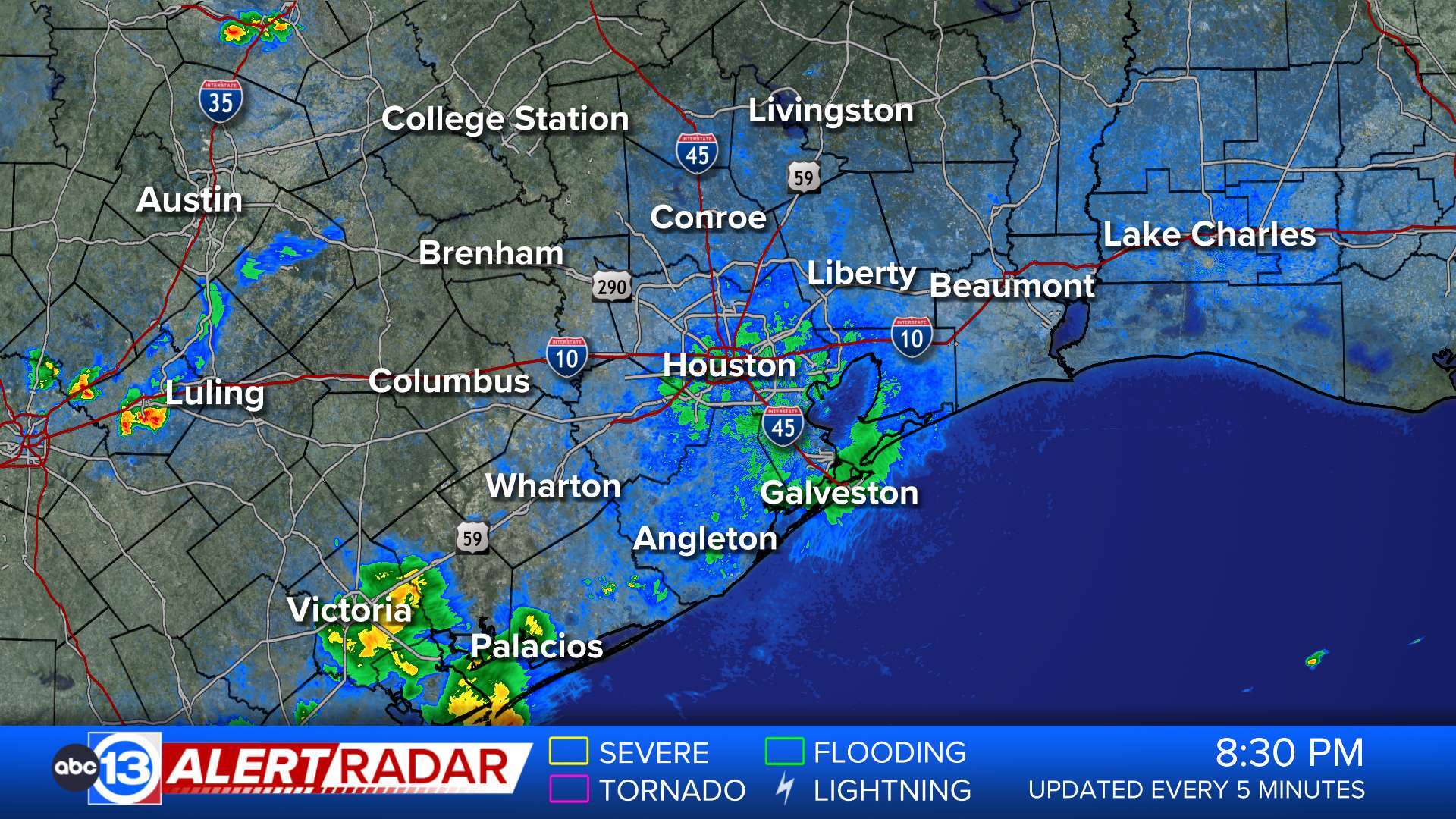
ABC13 Houston Weather Radar for Southeast Texas
Show More

Weather News
Show More

Travel Planner


  • Flood Warning

    ...The National Weather Service in Houston/Galveston TX has issued a Flood Warning for the following rivers in Texas... Cypress Creek Near Sharp Road affecting Harris and Fort Bend Counties. For the Cypress Creek...including Sharp Road...Minor flooding is forecast. * WHAT...Minor flooding is forecast. * WHERE...Cypress Creek near Sharp Road. * WHEN...From late tonight to early Sunday morning. * ADDITIONAL DETAILS... - At 9:20 PM CDT Thursday the stage was 158.3 feet. - Bankfull stage is 164.2 feet. - Forecast...The river is expected to rise above flood stage just after midnight tonight to a crest of 165.7 feet late tomorrow morning. It will then fall below flood stage Saturday afternoon. - Flood stage is 164.2 feet. - Flood History...This crest compares to a previous crest of 165.8 feet on 04/28/2009. - http://www.weather.gov/safety/floodMore

  • Flood Warning

    ...The Flood Warning continues for the following rivers in Texas... East Fork San Jacinto at Cleveland affecting San Jacinto, Harris, Montgomery and Liberty Counties. East Fork San Jacinto near New Caney affecting Harris, Montgomery and Liberty Counties. Peach Creek at Splendora affecting Harris and Montgomery Counties. Caney Creek near Splendora affecting Harris and Montgomery Counties. West Fork San Jacinto near Humble affecting Harris and Montgomery Counties. West Fork San Jacinto near Conroe affecting Montgomery County. ...The Flood Warning is extended for the following rivers in Texas... Lake Creek at Sendera Ranch Road affecting Montgomery County. West Fork San Jacinto near Porter affecting Montgomery County. For the East Fork San Jacinto River...including Cleveland, New Caney...Major flooding is forecast. For the Peach Creek...including Splendora...Major flooding is forecast. For the West Fork San Jacinto River...including Porter, Sendera Ranch Road, Conroe, Humble, Sheldon...Major flooding is forecast. * WHAT...Major flooding is occurring. * WHERE...West Fork San Jacinto near Conroe. * WHEN...Until tomorrow morning. * IMPACTS...At 117.8 feet, Major lowland flooding begins. * ADDITIONAL DETAILS... - At 8:15 PM CDT Thursday the stage was 119.2 feet. - Bankfull stage is 113.8 feet. - Recent Activity...The maximum river stage in the 24 hours ending at 8:15 PM CDT Thursday was 119.2 feet. - Forecast...The river is expected to rise to a crest of 115.3 feet early Saturday morning. - Flood stage is 115.8 feet. - Flood History...This crest compares to a previous crest of 119.1 feet on 04/25/1952. - http://www.weather.gov/safety/floodMore

  • Flood Warning

    ...The Flood Warning continues for the following rivers in Texas... East Fork San Jacinto at Cleveland affecting San Jacinto, Harris, Montgomery and Liberty Counties. East Fork San Jacinto near New Caney affecting Harris, Montgomery and Liberty Counties. Peach Creek at Splendora affecting Harris and Montgomery Counties. Caney Creek near Splendora affecting Harris and Montgomery Counties. West Fork San Jacinto near Humble affecting Harris and Montgomery Counties. West Fork San Jacinto near Conroe affecting Montgomery County. ...The Flood Warning is extended for the following rivers in Texas... Lake Creek at Sendera Ranch Road affecting Montgomery County. West Fork San Jacinto near Porter affecting Montgomery County. For the East Fork San Jacinto River...including Cleveland, New Caney...Major flooding is forecast. For the Peach Creek...including Splendora...Major flooding is forecast. For the West Fork San Jacinto River...including Porter, Sendera Ranch Road, Conroe, Humble, Sheldon...Major flooding is forecast. * WHAT...Major flooding is occurring and major flooding is forecast. * WHERE...Caney Creek near Splendora. * WHEN...Until early Saturday afternoon. * IMPACTS...At 24.0 feet, FM 2090 begins to take on water. * ADDITIONAL DETAILS... - At 8:30 PM CDT Thursday the stage was 22.6 feet. - Bankfull stage is 13.0 feet. - Recent Activity...The maximum river stage in the 24 hours ending at 8:30 PM CDT Thursday was 22.6 feet. - Forecast...The river will fall to 21.5 feet late this evening. It will then rise to 23.9 feet late tonight. It will fall below flood stage early Saturday morning to 5.8 feet early Tuesday morning. It will then rise to 5.9 feet early Tuesday morning. It will fall again and remain below flood stage. - Flood stage is 17.0 feet. - Flood History...This crest compares to a previous crest of 24.0 feet on 04/30/1953. - http://www.weather.gov/safety/floodMore

  • Flood Warning

    ...The Flood Warning continues for the following rivers in Texas... East Fork San Jacinto at Cleveland affecting San Jacinto, Harris, Montgomery and Liberty Counties. East Fork San Jacinto near New Caney affecting Harris, Montgomery and Liberty Counties. Peach Creek at Splendora affecting Harris and Montgomery Counties. Caney Creek near Splendora affecting Harris and Montgomery Counties. West Fork San Jacinto near Humble affecting Harris and Montgomery Counties. West Fork San Jacinto near Conroe affecting Montgomery County. ...The Flood Warning is extended for the following rivers in Texas... Lake Creek at Sendera Ranch Road affecting Montgomery County. West Fork San Jacinto near Porter affecting Montgomery County. For the East Fork San Jacinto River...including Cleveland, New Caney...Major flooding is forecast. For the Peach Creek...including Splendora...Major flooding is forecast. For the West Fork San Jacinto River...including Porter, Sendera Ranch Road, Conroe, Humble, Sheldon...Major flooding is forecast. * WHAT...Minor flooding is occurring and major flooding is forecast. * WHERE...Peach Creek at Splendora. * WHEN...Until late Saturday evening. * IMPACTS...At 20.5 feet, Texas Vehicle Inspection Station becomes threatened. * ADDITIONAL DETAILS... - At 9:00 PM CDT Thursday the stage was 15.9 feet. - Bankfull stage is 12.0 feet. - Recent Activity...The maximum river stage in the 24 hours ending at 9:00 PM CDT Thursday was 16.0 feet. - Forecast...The river is expected to rise to a crest of 20.6 feet late tomorrow morning. It will then fall below flood stage late Saturday morning. - Flood stage is 14.0 feet. - Flood History...This crest compares to a previous crest of 20.7 feet on 05/26/1944. - http://www.weather.gov/safety/floodMore

  • Flood Warning

    ...The Flood Warning continues for the following rivers in Texas... East Fork San Jacinto at Cleveland affecting San Jacinto, Harris, Montgomery and Liberty Counties. East Fork San Jacinto near New Caney affecting Harris, Montgomery and Liberty Counties. Peach Creek at Splendora affecting Harris and Montgomery Counties. Caney Creek near Splendora affecting Harris and Montgomery Counties. West Fork San Jacinto near Humble affecting Harris and Montgomery Counties. West Fork San Jacinto near Conroe affecting Montgomery County. ...The Flood Warning is extended for the following rivers in Texas... Lake Creek at Sendera Ranch Road affecting Montgomery County. West Fork San Jacinto near Porter affecting Montgomery County. For the East Fork San Jacinto River...including Cleveland, New Caney...Major flooding is forecast. For the Peach Creek...including Splendora...Major flooding is forecast. For the West Fork San Jacinto River...including Porter, Sendera Ranch Road, Conroe, Humble, Sheldon...Major flooding is forecast. * WHAT...Minor flooding is occurring and major flooding is forecast. * WHERE...East Fork San Jacinto at Cleveland. * WHEN...From this evening to early Sunday morning. * IMPACTS...At 25.0 feet, Lowest homes on Wells Road become threatened. * ADDITIONAL DETAILS... - At 8:30 PM CDT Thursday the stage was 20.9 feet. - Bankfull stage is 13.0 feet. - Recent Activity...The maximum river stage in the 24 hours ending at 8:30 PM CDT Thursday was 20.9 feet. - Forecast...The river is expected to rise to a crest of 24.6 feet tomorrow afternoon. It will then fall below flood stage early Saturday afternoon. - Flood stage is 19.0 feet. - Flood History...This crest compares to a previous crest of 24.6 feet on 01/08/1998. - http://www.weather.gov/safety/floodMore

  • Flood Warning

    ...The Flood Warning continues for the following rivers in Texas... East Fork San Jacinto at Cleveland affecting San Jacinto, Harris, Montgomery and Liberty Counties. East Fork San Jacinto near New Caney affecting Harris, Montgomery and Liberty Counties. Peach Creek at Splendora affecting Harris and Montgomery Counties. Caney Creek near Splendora affecting Harris and Montgomery Counties. West Fork San Jacinto near Humble affecting Harris and Montgomery Counties. West Fork San Jacinto near Conroe affecting Montgomery County. ...The Flood Warning is extended for the following rivers in Texas... Lake Creek at Sendera Ranch Road affecting Montgomery County. West Fork San Jacinto near Porter affecting Montgomery County. For the East Fork San Jacinto River...including Cleveland, New Caney...Major flooding is forecast. For the Peach Creek...including Splendora...Major flooding is forecast. For the West Fork San Jacinto River...including Porter, Sendera Ranch Road, Conroe, Humble, Sheldon...Major flooding is forecast. * WHAT...Moderate flooding is forecast. * WHERE...West Fork San Jacinto near Porter. * WHEN...From late tonight to late Monday morning. * IMPACTS...At 92.0 feet, Major lowland flooding begins in the vicinty of the gauge with low point on SH99 inundated. * ADDITIONAL DETAILS... - At 8:45 PM CDT Thursday the stage was 78.4 feet. - Bankfull stage is 73.0 feet. - Forecast...The river is expected to rise above flood stage late tonight to a crest of 90.8 feet late Saturday morning. It will then fall below flood stage late Sunday evening. - Flood stage is 81.0 feet. - Flood History...No available flood history. - http://www.weather.gov/safety/floodMore

  • Flood Warning

    ...The Flood Warning continues for the following rivers in Texas... East Fork San Jacinto at Cleveland affecting San Jacinto, Harris, Montgomery and Liberty Counties. East Fork San Jacinto near New Caney affecting Harris, Montgomery and Liberty Counties. Peach Creek at Splendora affecting Harris and Montgomery Counties. Caney Creek near Splendora affecting Harris and Montgomery Counties. West Fork San Jacinto near Humble affecting Harris and Montgomery Counties. West Fork San Jacinto near Conroe affecting Montgomery County. ...The Flood Warning is extended for the following rivers in Texas... Lake Creek at Sendera Ranch Road affecting Montgomery County. West Fork San Jacinto near Porter affecting Montgomery County. For the East Fork San Jacinto River...including Cleveland, New Caney...Major flooding is forecast. For the Peach Creek...including Splendora...Major flooding is forecast. For the West Fork San Jacinto River...including Porter, Sendera Ranch Road, Conroe, Humble, Sheldon...Major flooding is forecast. * WHAT...Moderate flooding is occurring and major flooding is forecast. * WHERE...East Fork San Jacinto near New Caney. * WHEN...Until early Tuesday afternoon. * IMPACTS...At 76.2 feet, Flood of record. * ADDITIONAL DETAILS... - At 9:00 PM CDT Thursday the stage was 67.4 feet. - Bankfull stage is 54.5 feet. - Recent Activity...The maximum river stage in the 24 hours ending at 9:00 PM CDT Thursday was 67.8 feet. - Forecast...The river is expected to rise to a crest of 76.8 feet Saturday morning. It will then fall below flood stage early Tuesday morning. - Flood stage is 58.0 feet. - Flood History...This crest compares to a previous crest of 76.0 feet on 10/19/1994. - http://www.weather.gov/safety/floodMore

  • Flood Warning

    ...The Flood Warning continues for the following rivers in Texas... East Fork San Jacinto at Cleveland affecting San Jacinto, Harris, Montgomery and Liberty Counties. East Fork San Jacinto near New Caney affecting Harris, Montgomery and Liberty Counties. Peach Creek at Splendora affecting Harris and Montgomery Counties. Caney Creek near Splendora affecting Harris and Montgomery Counties. West Fork San Jacinto near Humble affecting Harris and Montgomery Counties. West Fork San Jacinto near Conroe affecting Montgomery County. ...The Flood Warning is extended for the following rivers in Texas... Lake Creek at Sendera Ranch Road affecting Montgomery County. West Fork San Jacinto near Porter affecting Montgomery County. For the East Fork San Jacinto River...including Cleveland, New Caney...Major flooding is forecast. For the Peach Creek...including Splendora...Major flooding is forecast. For the West Fork San Jacinto River...including Porter, Sendera Ranch Road, Conroe, Humble, Sheldon...Major flooding is forecast. * WHAT...Major flooding is occurring and major flooding is forecast. * WHERE...West Fork San Jacinto near Humble. * WHEN...Until early Wednesday morning. * ADDITIONAL DETAILS... - At 8:45 PM CDT Thursday the stage was 53.6 feet. - Bankfull stage is 15.0 feet. - Recent Activity...The maximum river stage in the 24 hours ending at 8:45 PM CDT Thursday was 53.6 feet. - Forecast...The river is expected to rise to a crest of 62.3 feet early Sunday morning. It will then fall below flood stage early Tuesday afternoon. - Flood stage is 49.3 feet. - Flood History...This crest compares to a previous crest of 62.0 feet on 05/29/2016. - http://www.weather.gov/safety/floodMore

  • Flood Warning

    ...The Flood Warning continues for the following rivers in Texas... East Fork San Jacinto at Cleveland affecting San Jacinto, Harris, Montgomery and Liberty Counties. East Fork San Jacinto near New Caney affecting Harris, Montgomery and Liberty Counties. Peach Creek at Splendora affecting Harris and Montgomery Counties. Caney Creek near Splendora affecting Harris and Montgomery Counties. West Fork San Jacinto near Humble affecting Harris and Montgomery Counties. West Fork San Jacinto near Conroe affecting Montgomery County. ...The Flood Warning is extended for the following rivers in Texas... Lake Creek at Sendera Ranch Road affecting Montgomery County. West Fork San Jacinto near Porter affecting Montgomery County. For the East Fork San Jacinto River...including Cleveland, New Caney...Major flooding is forecast. For the Peach Creek...including Splendora...Major flooding is forecast. For the West Fork San Jacinto River...including Porter, Sendera Ranch Road, Conroe, Humble, Sheldon...Major flooding is forecast. * WHAT...Minor flooding is occurring and moderate flooding is forecast. * WHERE...Lake Creek at Sendera Ranch Road. * WHEN...Until further notice. * ADDITIONAL DETAILS... - At 8:45 PM CDT Thursday the stage was 138.4 feet. - Bankfull stage is 129.0 feet. - Recent Activity...The maximum river stage in the 24 hours ending at 8:45 PM CDT Thursday was 138.6 feet. - Forecast...The river is expected to rise to a crest of 145.6 feet early tomorrow afternoon. - Flood stage is 138.0 feet. - Flood History...No available flood history. - http://www.weather.gov/safety/floodMore

  • Flood Warning

    ...The Flood Warning continues for the following rivers in Texas... Menard Creek near Rye affecting Hardin, Liberty and Polk Counties. Long King Creek near Livingston affecting San Jacinto and Polk Counties. Trinity River near Romayor affecting San Jacinto, Liberty and Polk Counties. Trinity River at Liberty affecting Liberty County. Trinity River near Goodrich affecting San Jacinto, Liberty and Polk Counties. Trinity River near Moss Bluff affecting Liberty and Chambers Counties. Trinity River at Riverside affecting San Jacinto, Trinity, Polk and Walker Counties. For the Trinity River...including Crockett, Riverside, Romayor, Goodrich, Liberty, Moss Bluff...Major flooding is forecast. For the Menard Creek...including Rye...Major flooding is forecast. * WHAT...Moderate flooding is occurring and moderate flooding is forecast. * WHERE...Long King Creek near Livingston. * WHEN...Until early Saturday morning. * IMPACTS...At 25.0 feet, At levels above 25 feet moderate lowland flooding begins as low lying areas along the creek become innundated. * ADDITIONAL DETAILS... - At 9:01 PM CDT Thursday the stage was 26.5 feet. - Bankfull stage is 14.0 feet. - Recent Activity...The maximum river stage in the 24 hours ending at 9:01 PM CDT Thursday was 27.4 feet. - Forecast...The river is expected to fall below flood stage tomorrow afternoon and continue falling to 4.3 feet Tuesday evening. - Flood stage is 19.0 feet. - Flood History...This crest compares to a previous crest of 26.6 feet on 06/07/1981. - http://www.weather.gov/safety/floodMore

  • Flood Warning

    ...The Flood Warning continues for the following rivers in Texas... Menard Creek near Rye affecting Hardin, Liberty and Polk Counties. Long King Creek near Livingston affecting San Jacinto and Polk Counties. Trinity River near Romayor affecting San Jacinto, Liberty and Polk Counties. Trinity River at Liberty affecting Liberty County. Trinity River near Goodrich affecting San Jacinto, Liberty and Polk Counties. Trinity River near Moss Bluff affecting Liberty and Chambers Counties. Trinity River at Riverside affecting San Jacinto, Trinity, Polk and Walker Counties. For the Trinity River...including Crockett, Riverside, Romayor, Goodrich, Liberty, Moss Bluff...Major flooding is forecast. For the Menard Creek...including Rye...Major flooding is forecast. * WHAT...Major flooding is occurring and major flooding is forecast. * WHERE...Trinity River at Liberty. * WHEN...Until further notice. * ADDITIONAL DETAILS... - At 8:15 PM CDT Thursday the stage was 30.4 feet. - Bankfull stage is 21.0 feet. - Recent Activity...The maximum river stage in the 24 hours ending at 8:15 PM CDT Thursday was 30.4 feet. - Forecast...The river is expected to rise to a crest of 32.0 feet Monday morning. - Flood stage is 26.0 feet. - Flood History...This crest compares to a previous crest of 32.7 feet on 09/01/2017. - http://www.weather.gov/safety/floodMore

  • Flood Warning

    ...The Flood Warning continues for the following rivers in Texas... Menard Creek near Rye affecting Hardin, Liberty and Polk Counties. Long King Creek near Livingston affecting San Jacinto and Polk Counties. Trinity River near Romayor affecting San Jacinto, Liberty and Polk Counties. Trinity River at Liberty affecting Liberty County. Trinity River near Goodrich affecting San Jacinto, Liberty and Polk Counties. Trinity River near Moss Bluff affecting Liberty and Chambers Counties. Trinity River at Riverside affecting San Jacinto, Trinity, Polk and Walker Counties. For the Trinity River...including Crockett, Riverside, Romayor, Goodrich, Liberty, Moss Bluff...Major flooding is forecast. For the Menard Creek...including Rye...Major flooding is forecast. * WHAT...Major flooding is forecast. * WHERE...Trinity River near Romayor. * WHEN...Until further notice. * ADDITIONAL DETAILS... - At 8:30 PM CDT Thursday the stage was 40.0 feet. - Bankfull stage is 30.0 feet. - Forecast...The river is expected to rise to a crest of 45.9 feet early tomorrow afternoon. - Flood stage is 40.0 feet. - Flood History...No available flood history. - http://www.weather.gov/safety/floodMore

  • Flood Warning

    ...The Flood Warning continues for the following rivers in Texas... Menard Creek near Rye affecting Hardin, Liberty and Polk Counties. Long King Creek near Livingston affecting San Jacinto and Polk Counties. Trinity River near Romayor affecting San Jacinto, Liberty and Polk Counties. Trinity River at Liberty affecting Liberty County. Trinity River near Goodrich affecting San Jacinto, Liberty and Polk Counties. Trinity River near Moss Bluff affecting Liberty and Chambers Counties. Trinity River at Riverside affecting San Jacinto, Trinity, Polk and Walker Counties. For the Trinity River...including Crockett, Riverside, Romayor, Goodrich, Liberty, Moss Bluff...Major flooding is forecast. For the Menard Creek...including Rye...Major flooding is forecast. * WHAT...Major flooding is occurring and major flooding is forecast. * WHERE...Trinity River near Goodrich. * WHEN...Until further notice. * ADDITIONAL DETAILS... - At 8:45 PM CDT Thursday the stage was 46.5 feet. - Bankfull stage is 36.0 feet. - Recent Activity...The maximum river stage in the 24 hours ending at 8:45 PM CDT Thursday was 46.5 feet. - Forecast...The river is expected to rise to a crest of 49.0 feet tomorrow morning. - Flood stage is 36.0 feet. - Flood History...This crest compares to a previous crest of 49.0 feet on 10/18/1994. - http://www.weather.gov/safety/floodMore

  • Flood Warning

    ...The Flood Warning continues for the following rivers in Texas... Menard Creek near Rye affecting Hardin, Liberty and Polk Counties. Long King Creek near Livingston affecting San Jacinto and Polk Counties. Trinity River near Romayor affecting San Jacinto, Liberty and Polk Counties. Trinity River at Liberty affecting Liberty County. Trinity River near Goodrich affecting San Jacinto, Liberty and Polk Counties. Trinity River near Moss Bluff affecting Liberty and Chambers Counties. Trinity River at Riverside affecting San Jacinto, Trinity, Polk and Walker Counties. For the Trinity River...including Crockett, Riverside, Romayor, Goodrich, Liberty, Moss Bluff...Major flooding is forecast. For the Menard Creek...including Rye...Major flooding is forecast. * WHAT...Minor flooding is occurring and major flooding is forecast. * WHERE...Trinity River near Moss Bluff. * WHEN...Until further notice. * IMPACTS...At 17.2 feet, Major lowland flooding bengins in the vicinity of the gage. * ADDITIONAL DETAILS... - At 8:30 PM CDT Thursday the stage was 15.0 feet. - Bankfull stage is 9.2 feet. - Recent Activity...The maximum river stage in the 24 hours ending at 8:30 PM CDT Thursday was 15.0 feet. - Forecast...The river is expected to rise to a crest of 15.1 feet just after midnight tonight. It will then rise to 17.5 feet Tuesday evening. Additional rises are possible thereafter. - Flood stage is 12.2 feet. - Flood History...This crest compares to a previous crest of 18.7 feet on 09/01/2017. - http://www.weather.gov/safety/floodMore

  • Flood Watch

    * WHAT...Flooding caused by excessive rainfall continues to be possible. * WHERE...A portion of southeast Texas, including the following areas, Brazos, Burleson, Coastal Harris, Grimes, Houston, Inland Harris, Madison, Montgomery, Northern Liberty, Polk, San Jacinto, Southern Liberty, Trinity, Walker, Waller and Washington. * WHEN...Through Friday evening. * IMPACTS...Excessive runoff may result in flooding of rivers, creeks, streams, and other low-lying and flood-prone locations. Flooding may occur in poor drainage and urban areas. Low-water crossings may be flooded. * ADDITIONAL DETAILS... - Though heavy rain has waned this afternoon, the environment remains favorable for additional heavy rainfall. Model guidance suggests potential for heavier rains in the watch area overnight and tomorrow. Any further rainfall would at best slow the recission of existing floodwaters, and at worst would aggravate this flooding. Saturated soils will result in a greater risk of flash flooding, even at rain rates that typically do not cause problems in this area. 1-2 inches of new rainfall are possible with isolated totals of up to 3-4 inches. - http://www.weather.gov/safety/floodMore

  • Flood Warning

    Flooding continues across portions of Southeast Texas in the wake of rounds of heavy rain and thunderstorms. Though heavy rain has ended for now, flooding is still ongoing while waters gradually drain. Please continue to use caution while traveling - especially at night - and heed the advice of local officials. If you encounter flooded roads while traveling, turn around and find another way. * WHAT...Urban area and small stream flooding caused by excessive rainfall is occurring. * WHERE...A portion of southeast Texas, including the following counties, Chambers, Harris, Liberty and Montgomery. * WHEN...Until 700 AM CDT Friday. * IMPACTS...Flooding of rivers, creeks, streams, and other low-lying and flood-prone locations is imminent or occurring. Numerous roads remain closed due to flooding. Low-water crossings are inundated with water and may not be passable. Expect many areas of slow moving or standing water. It will take several hours for all the water from these storms to work through local drainage systems in urban areas. Local media have reported water rescues. * ADDITIONAL DETAILS... - At 500 PM CDT, Flooding has been reported in locations across the warned area. - Some locations that will experience flooding include... Southern Conroe, Humble, Tomball, Liberty, Dayton, Kingwood, Spring, Aldine, Greater Greenspoint, The Woodlands, Crosby, Oak Ridge North, Shenandoah, Splendora, Patton Village, Roman Forest, Woodbranch, Ames, Daisetta and Hardin. - http://www.weather.gov/safety/floodMore


Download the ABC13 News app!

Live Web Cams

Weather Team