Tropical Depression 2 forms in the Gulf, Texas could be impacted


July 19 10AM Update
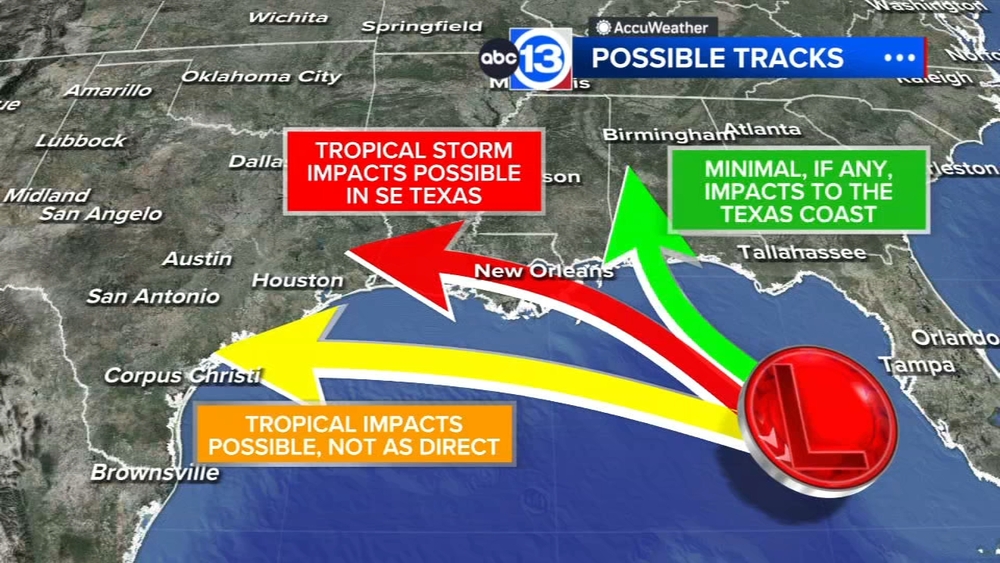
Tropical Depression Two has officially formed in the eastern Gulf, and it's expected to strengthen into Tropical Storm Bertha within the next 48 hours. The current NHC track has the storm drifting slowly northwestward through Tuesday, then accelerating west beyond that. If the storm does impact Texas, we are likely looking at a Thursday-to-Friday timeframe.
There's still a fair amount of uncertainty regarding the exact eventual path of this storm, and hurricane hunters are scheduled to fly through the storm today to gather data.
July 19 Update
Development odds on our eastern Gulf disturbance continue to climb, now up to 80%, and it is likely we will have a tropical depression or Tropical Storm Bertha in the next 24 hours. The National Hurricane Center included this tidbit in their tropical outlook: "interests along the northern Gulf coast from Florida, Alabama, Mississippi, and Louisiana should monitor this system", with "Texas" being notably absent from that statement. That's because the likely outcome from this system remains a progression to the northwest, eventually impacting areas between the Florida panhandle and Louisiana. While an impact to Texas is currently unlikely, it is not currently impossible (a few models actually do favor a more westward path). If the storm were to continue farther west into Texas, our impact timeframe would likely be around Thursday of this week, but again I'll stress that a Texas impact is an unlikely outcome. Hurricane hunters flying through the storm today will give us a better idea on the structure of the storm and the eventual destination.
July 18 Update
We're keeping a close watch on an area of potential development in the eastern Gulf. Current development odds are up to 30% over the next 7 days. There is still some uncertainty regarding where exactly this developing low pressure will end up, though most forecast models slowly drift it north and keep it far away from Texas. It remains worthy of watching in the coming days in case more models try to pull it west, but the overall concern level is fairly low for us here in Texas.
July 17 Update
An area of deep tropical moisture in the eastern Gulf has a 20% chance for development according to the National Hurricane Center. This moisture and developing system could drift west in our general direction, but high pressure building over Texas should help steer any potential storms away from Texas and into Mexico. Elsewhere, a weak system in the eastern Atlantic just rolling off the coast of Africa near the Cabo Verde islands has just a 10% chance of development.
July 16 Update
We are monitoring two areas for tropical development over the next seven days. The National Hurricane Center has tagged a potential development zone in the eastern Gulf. Formation odds are low for now at twenty percent. If anything develops in this area, it would most likely move toward the Florida Panhandle. The other area is over the eastern Atlantic near the Cabo Verde Islands. This system has a ten percent for development over the next seven days.
In the eastern Pacific, Tropical Storm Elida continues to spin away from the southwest coast of Mexico. This system is expected to strengthen over the next several days but remain over water. No impacts to land at this time.
July 15 Update
The National Hurricane Center has tagged a potential development zone in the eastern Gulf. Formation odds are low for now at twenty percent. If anything develops in this area, it would most likely move toward the Florida Panhandle.
In the eastern Pacific, Tropical Storm Elida has formed off the southwest coast of Mexico. This system is expected to strengthen over the next several days but remain over water. No impacts to land at this time.
July 14 Update
No tropical development expected over the next 7 days over the Atlantic, Caribbean or Gulf. A large plume of Saharan dust remains in place this week, so development looks unlikely.
The Pacific remains active with numerous tropical waves that could develop into a tropical depression or named storm this week. No impacts to land is anticipated at this time.
July 13 Update
The Tropics are still quiet with no tropical development expected over the next 7 days. A large plume of Saharan dust remains in place this week, so development looks unlikely.
The Pacific remains active with several tropical waves that could develop into a tropical depression or named storm this week. No impacts to land is anticipated at this time.
July 12 Update
Some Saharan dust and wind shear is keeping the tropics quiet, just like we like it. No tropical development is expected over the next 7 days. A swath of Saharan dust could push this way early next week and linger in the Gulf (and here in SE Texas) for the next week.
July 11 Update
No tropical development is expected over the next week as our quiet start to hurricane season continues. An increase in Saharan Dust early next week could cause some lung irritation for those with respiratory issues, and, when combined with rain, could leave some dusty residue on our cars.
July 10 Update
The Tropics are still quiet with no tropical development expected over the next 7 days. A plume of Saharan dust arrives early next week, and with elevated rain chances and dust in place, we could see some dusty residue left on our cars after a downpour.
July 9 Update
No tropical development is expected over the Atlantic basin during the next seven day as we track another large plume of Saharan dust.
July 8 Update
Tropical development looks unlikely over the seven day as we track a large plume of Saharan dust that could eventually impact us here in Southeast Texas later this week.
In the Eastern Pacific, low pressure is expected to form late this weekend or early next week south of the coast of southwestern Mexico. Gradual development is possible as the system moves west-northwestward. Formation odds have climbed to forty percent.
July 7 Update
In the Atlantic basin, conditions remain quiet and no tropical development is expected during the next seven day as we track another large plume of Saharan dust that could eventually impact us here in Southeast Texas later this week.
In the Eastern Pacific, low pressure is expected to form late this weekend or early next week south of the coast of southwestern Mexico. Gradual development is possible as the system moves west-northwestward. Formation odds are at twenty percent.
July 6 Update
No tropical development is expected over the Atlantic basin during the next seven day as we track another large plume of Saharan dust that could eventually impact us here in Southeast Texas later this week.
July 5 Update
All quiet! No Tropical Development is expected over the next 7 days. Part of the reason for the lack of development if a thick plume of Saharan dust in the Atlantic and Caribbean. That dust could end up right here in Southeast Texas by Thursday.
July 4 Update
First and foremost, no tropical development is expected in the Atlantic basic over the next week. That's always a big win. Outside of there we're watching for another plume of Saharan dust that could arrive towards the end of this upcoming week. We'll keep an eye on it and keep you updated.
July 3 Update
No tropical development is expected over the Atlantic basin during the next seven day as we track another large plume of Saharan dust that could eventually impact us here in Southeast Texas late next week.
Tropical Storm Douglas has weakened in the eastern Pacific and is not expected to affect land. South of Douglas, a tropical wave has a low chance for tropical development during the next seven days. Formation odds at 20 percent.
July 2 Update
In the Atlantic, no tropical development is expected over the next seven day as we track another large plume of Saharan dust that could eventually impact us here in Southeast Texas late next week.
Tropical Storm Douglas is in the eastern Pacific and is not expected to have any impacts on land. Douglas is expected to weaken into a tropical depression Thursday night.
July 1 Update
There is no longer a risk of tropical development off the Southeast coast. Otherwise, a large plume of Saharan dust is expected to cover much of the Atlantic Basin which would limit or prevent tropical development from occurring over the next seven days. Meanwhile, Tropical Depression Four-E forms in the eastern Pacific. Some strengthening is forecast and the system is forecast to become a tropical storm later today or tonight. No impacts to land expected.
June 30 Update
The tropics remain relatively quiet for the end of June and heading into July. That's partly thanks to Saharan dust, the most recent haze over Southeast Texas Monday. There is one region in each basin though to watch for possible development over the next 7 days. An area off the east coast of the Carolinas has a low chance of developing into a tropical system this week, while in the Pacific there a swirling area of thunderstorms that could become the next named storm of the season for the basin. Long term tropical outlooks over the next 2 to 3 weeks also keep the Atlantic Basin quiet.
June 29 Update
We have a hazy sky across Southeast Texas today thanks to a fairly thick plume of Saharan dust that started moving into Southeast Texas late yesterday. The hazy not only impacts the sky, but is a lung irritant as well, so those with asthma or allergies may want to limit their time outdoors today. Thankfully, the dust will clear out by tomorrow and conditions will return to normal. While we wait for the literal dust to settle, we are also keeping an eye on an area of potential tropical development off the southeast coast of the United States. Thankfully, development odds are low, just a 10% chance. We'll keep an eye on things, but are not anticipating any real trouble.
June 28 Update
Saharan dust moves in today, making for a hazy sky and impacting air quality. The haze will be noticeable by sunset, and will be thickest on Monday. Anyone with respiratory issues may want to limit their time outside from tonight through Monday if possible. Elsewhere, we have an area of potential tropical development off the eastern seaboard, but the NHC has development odds at just 20%, and there is no direct threat to Texas regardless.
June 27 Update
We'll start with the good news: No tropical development is expected in the Atlantic Basin over the next 7 days. Part of the reason for the lack of development has been a large plume of Saharan dust, but that dust is now headed our way. You may start to notice that dust by Sunday evening, but even higher concentrations will be in place throughout the day on Monday. If you have asthma or allergies you may want to limit your time outside on Monday.
June 26 Update
We continue to track a large plume of Saharan dust moving into the Gulf this weekend. No tropical development is expected over the next seven days. However, that large dust plume will eventually impact us here in Southeast Texas by early next week.
Meanwhile, in the Eastern Pacific a tropical wave located off the southwestern coast of Mexico continues to produce disorganized shower and thunderstorm activity. This system is expected to encounter more favorable conditions for development over the weekend and a tropical depression is likely to form by the early to middle part of next week.
June 25 Update
A large plume of Saharan dust continues to cover much of the Atlantic Basin which would limit or prevent tropical development from occurring over the next seven days. However, one of the plumes we've been tracking will eventually impact us here in Southeast Texas by early next week.
In the Pacific, there is a large area of showers and thunderstorms located off the coast of southwestern Mexico. A low pressure system is likely to form this weekend or early next week. Environmental conditions are forecast to be favorable for gradual development, and a tropical depression is likely to form by the early to middle part of next week as the system moves westward to west-northwestward at 10 to 15 mph.
June 24 Update
No tropical development is expected, however we're monitoring a few plumes of Saharan dust that could eventually impact us here in Southeast Texas over the next seven days.
In the Pacific, there is a large area of showers and thunderstorms located off the coast of southwestern Mexico. There's a medium risk of tropical development. Some slow development of this system is possible as it moves west at 10 to 15 mph. At this time, no threat to land.
June 23 Update
In the Atlantic, no tropical development is expected over the next seven days as a few plumes of Saharan dust is over the Atlantic basin that could eventually impact us here in Southeast Texas by next week.
In the Pacific, there is a large area of showers and thunderstorms located south-southwest of the coast of southwestern Mexico. There's a low to medium risk of tropical development. Some slow development of this system is possible as it moves west-northwestward at 10 to 15 mph. At this time, no threat to land.
June 22 Update
In the Atlantic, no tropical development is expected over the next seven day as a few plumes of Saharan dust is over the Atlantic basin that could eventually impact us here in Southeast Texas.
In the Pacific, there is a low risk of tropical development southwest of Mexico. Some slow development of this system is possible as it moves west-northwestward at 10 to 15 mph. At this time, no threat to land.
June 20 Update
Any moisture left over from Arthur has dissipated over the western Atlantic. The tropics are quiet for now as a large plume of Saharan dust covers much of the Atlantic basin and high wind shear is in place over the Caribbean and Gulf.
June 19 Update
NHC continues to monitor the remnants of Arthur. The system is expected to emerge offshore the east coast of the U.S. Friday afternoon. Environmental conditions then appear to be favorable for some subtropical or tropical development over the next day or two as the system moves northeastward at around 20 mph across the Western Atlantic Ocean.
Regardless of development, heavy rainfall with the potential for widespread and life-threatening flash flooding is likely across portions of the Southeast United States during the next day or two.
June 18 Update
Post Tropical Storm Arthur has dissipated, but its remnants will continue to track across eastern Louisiana Thursday where there could be significant and even life-threatening flooding in some areas, before spreading northeastward into portions of Georgia and the Carolinas. The National Hurricane Center says environmental conditions appear favorable for some subtropical or tropical development on Friday or Saturday, as the system moves northeastward at around 15 mph, and emerges offshore the east coast of the United States and into the Western Atlantic Ocean. Formation odds are 10% during the next seven days.
June 17 10 a.m. Update
Tropical Storm Arthur has formed just offshore of Southeast Texas with sustained winds of 40 mph, gusts up to 50 mph and a minimum central pressure of 1001 mb. This is the first storm of the 2026 Atlantic Hurricane Season. A Tropical Storm Warning remains in effect for coastal Brazoria, Galveston and all of Chambers County Wednesday. The main threats to Southeast Texas will reside closest to the coastline where tropical-storm force winds could lead to minor property damage and power outages and heavy rains could lead to flooding.
June 17 Update
Potential Storm One has emerged over the northwest Gulf Wednesday morning. NHC forecast track brings the system northeastward along the Texas coast and then moving inland over southwestern Louisiana by Wednesday night. Regardless, tropical downpours and tropical storm force winds will be ongoing through the evening and then calm as the storm lifts into Louisiana overnight. Rainfall totals of 4-7 inches possible, with isolated higher totals near 12 inches. Coastal flooding remains possible and dangerous storm surge through Wednesday evening.
June 16 4 p.m. Update
A Tropical Storm Watch is still in effect for coastal Brazoria, Galveston and all of Chambers County ahead of this tropical low moving offshore and potentially forming into Arthur Wednesday. The latest track from the hurricane center keeps Arthur's low pressure center close to the Texas coastline, tracking along Southeast Texas Wednesday. One small difference in the potential storm's intensity if that Potential Storm One could remain more of a tropical low or depression Wednesday morning and not strengthen into Arthur until later in the day Wednesday. There is also the possibility this tropical low never fully forms into a system too. However, we're still expecting some impacts along the coast. Wind gusts could range between 30 to 40 mph at times Wednesday for communities within the Tropical Storm watch. Elsewhere across SE Texas we could see gusts at times upwards to 25 to 30 mph. A storm surge of 1 to 4 feet Wednesday could also bring coastal flooding and even flash flooding when paired with heavy rains. There's also the chance for street and urban flooding, possibly flash flooding, in Houston and Harris County Wednesday depending on the tropical downpours that form with this system.
June 16 10:30 a.m. Update
NHC has issued its first advisory on Potential Storm One. The system is forecast to emerge into the northwest Gulf overnight and is expected strengthen into Tropical Storm Arthur. Rainfall: 4-8 inches will be widespread, with isolated totals up to 12". Flash flooding will continue until Thursday morning. A Tropical Storm Watch from Sargent, TX to Morgan City, LA. Storm surge of 2-4 feet possible along parts of the upper Texas and Louisiana coast. The system is expected to track near the Upper Texas Coast Wednesday, then make landfall near the Texas/Louisiana border late Wednesday into Thursday.
June 16
The National Hurricane Center is giving low pressure over South Texas a 60% chance of becoming a tropical depression or storm once it moves offshore on Wednesday. The system could re-emerge over the northwestern Gulf today, and environmental conditions are expected to be marginally conducive for the formation of a short-lived tropical storm later today or on Wednesday. The track of that low will determine how much rainfall we get Wednesday and Thursday.
June 15 1 p.m. Update
The disturbance currently in northeastern Mexico now has 50% odds of forming into a tropical depression or storm as it moves into the northwestern Gulf on Wednesday. This system would likely form just offshore of the Texas coast midweek, sometime Wednesday or Thursday, then quickly move onshore a day or so later. Still, the main impacts that would face those of us in Southeast Texas would be the potential for widespread street flooding and the possibility for life-threatening flash flooding prompted by heavy, tropical downpours. Tropical Storm Watches and Warnings could be issued for parts of Texas and Louisiana as early as Tuesday. The Hurricane Hunters are scheduled to fly into this disturbance Tuesday night and Wednesday morning.
June 15
A disturbance over northeastern Mexico continues to produce disorganized showers and thunderstorms, but development is not expected during the next day or so while it remains inland. The system is expected to move northeastward and could re-emerge over the northwestern Gulf Tuesday or Wednesday, where environmental conditions may support some development around midweek. Regardless of development, an increase in storm chances and potentially heavy rainfall is expected for Southeast Texas as the disturbance gets closer.
June 14
No doubt that deeper tropical moisture is now in place across Southeast Texas. You can feel the increase in humidity, and you can see the increase in rain chances as well. That deeper moisture sticks around through at least Tuesday, but it's mid-week when things get a bit more interesting in the Gulf. A disturbance currently located over Mexico could drift back into the Gulf on Wednesday, and there is some model support for it becoming a loosely organized low pressure system as it rides along the Texas Gulf Coast. Right now the National Hurricane Center has placed 20% development odds on this system, with a 0% chance of development by Tuesday. Regardless of development, we will need to keep an eye on this for increase rain chances and potentially heavy rain around Thursday as the disturbance gets closer to Southeast Texas.
June 13
The National Hurricane Center has tagged an area of deep tropical moisture in the western Gulf with a 20% chance of topical development. Regardless of any development (which looks highly unlikely), it will work to spread an increase in moisture our way in the coming days, increasing our rain chances Sunday/Monday/Tuesday.
June 12
We're monitoring the Bay of Campeche over the next couple of days as a broad area of low pressure could form. Development odds are low at 10 percent. While it doesn't look very likely to become anything tropical, it could work with a cold front to spread some widespread moisture our way by the weekend into early next week.
June 11
Cristina has dissipated in the Pacific, but the remnant moisture is expected to move for the southwest Gulf over the weekend. The National Hurricane Center has given the remnants of this storm a 10% chance of re-forming into an Atlantic tropical system over the Bay of Campeche. That's the moisture that will bring Southeast Texas a high chance for heavy downpours and a risk of flash flooding Sunday through Tuesday.
June 10
We're monitoring the Bay of Campeche over the next few days as a broad area of low pressure could form. Development odds are low at 10 percent. While it doesn't look very likely to become anything tropical, it could work with a cold front to spread some widespread moisture our way by the weekend into early next week.
In the Pacific, Tropical Storm Cristina continues to swirl off the coast of El Salvador. Moisture from Cristina is expected to move into the Gulf over the weekend.
June 9
The Atlantic Basin remains quiet to start out the 2026 Atlantic Hurricane Season. While no development is expected over the next 7 days, we are keeping an eye on a swatch of deep moisture in the Gulf later this week. It doesn't look very likely to become an official tropical system, however it could work with the jet stream to spread some added moisture our way by the weekend. For now we're holding rain chances over the weekend at 30%, but if deeper moisture spreads this way those numbers will have to climb.
June 8
No Tropical Development is expected over the next 7 days, but that doesn't mean we don't have areas of interest that could impact our weather. Of greatest significance is an area of deeper tropical moisture in the Bay of Campeche late this week. While it doesn't look very likely to become an official tropical system, it could work with the jet stream to spread some added moisture our way by the weekend. For now we're holding rain chances over the weekend at 30%, but if deeper moisture spreads this way those numbers will have to climb.
June 7
The key story in the Tropics is that, for now, no tropical development is expected over the next 7 days. That's always a win, but it doesn't mean we are turning a blind eye to the Caribbean and Gulf. Deep tropical moisture is gathering in the Southern Gulf this week, and it's not completely out of the question that we get our first tropical depression from it. Regardless of development, we aren't certain where exactly that deeper moisture will end up. If it heads this way, you could see our rain chances climbing into next weekend.
June 6
The Atlantic Basin remains quiet to start out the 2026 Atlantic Hurricane Season. While no development is expected over the next 7 days, we are keeping an eye on a swatch of deep moisture in the Gulf later this upcoming week.
June 5
With Saharan dust in the deep tropics and high wind shear over the gulf and Caribbean, no tropics development is expected over the next 7 days in the Atlantic. Over in the Pacific, Tropical Storm Amanda continues to swirls in the middle of the eastern Pacific and poses no threat to land. There are also two potential areas of development off the west coast of Mexico to monitor over the next 7 days.
June 4
As expected, the first named storm of the Pacific Hurricane Season has formed. Tropical storm Amanda continues to swirl in the eastern Pacific Ocean with winds of 40 mph. The system is not expected to make landfall and is forecast to weaken to a tropical depression early next week. There's also two regions to watch for potential development off the west coast of Mexico. Meanwhile in the Atlantic, large plumes of Saharan dust keep the tropics quiet. No tropical development is expected over the next 7 days.
June 3
No tropical development is expected over the next 7 days across the Atlantic Basin, though we'll experience some heavy, tropical-like downpours at times this week and into the first weekend of June. Over in the Pacific Ocean, Tropical Depression One has formed and will likely strengthen into a tropical storm later today. This would become the first named storm of the season in the Pacific. There is also another area off the west coast of Mexico to watch over the next 7 days.
June 2
No tropical development is expected over the next 7 days across the Atlantic Basin. That being said, there is an area of deep tropical moisture over the Gulf that we're keeping an eye on. While the chance for any development remains low, the added moisture streaming this way should increase our rain chances into the weekend. Over in the Pacific Ocean, there are two areas of potential development over the next 7 days with the first named storm of the season possibly developing by the end of the week.
June 1
The 2026 Atlantic Hurricane Season has officially begun! Thankfully, there is no tropical development expected over the next 7 days, so officially we're off to a "quiet" start. That being said, there is an area of deep tropical moisture over the Gulf that we're keeping an eye on. While the chance for any development remains low, the added moisture streaming this way should increase our rain chances through the work week.
NOAA is forecasting a 55% chance of having a below average storm total this year due an El Nino pattern which typically brings higher wind shear and fewer storms in the Caribbean and Gulf, but that doesn't mean we are in the clear. In fact there are many cases of "below average" storm total years bringing devastating hurricanes to the United States. It only takes one, so as always, prepare for the worst and hope for the best. Now is a great time to make sure you have any hurricane preps and plans in order. It's never fun to think about hurricane season, but it's much easier to do now than it is when a storm is threatening.
May 26
The 2026 Atlantic Hurricane Season Outlook is here, and it hints at a potentially below-average season in terms of activity.
NOAA forecasters are predicting between eight to 14 named storms, three to six hurricanes, and one to three major hurricanes for the 2026 season. Each of these estimates is either at or slightly below the norm for each category.
So where do these numbers come from, and what could it mean for Texans? ABC13 Meteorologist Elyse Smith has more analysis and information on what this could mean for Houston.
The overarching reason for the strong signal pointing to a less active Atlantic hurricane season is the emerging El Niño in the Pacific. At the end of May, water temperatures in the equatorial Pacific Ocean are trending warmer than normal and could continue to warm into the summer months. This would signal that an El Niño has formed, and some long-range computer model guidance suggests this emerging El Niño could strengthen quickly and become a strong El Niño by later this year.
The importance of this phenomenon arriving at this time of year is that it can impact the jet stream over the United States, the Gulf, and the Caribbean. Typically, hurricane seasons with El Niño conditions have favored below-normal activity in the tropics due to wind shear. This is especially true for the Gulf and Caribbean. Wind shear can be a limiting factor in the formation and intensity of tropical storms.
So that's part of the equation. The other is to use historical references and comparisons with previous Atlantic hurricane seasons when similar conditions may have been present. These are called analog years. The analog years used to make the 2026 hurricane season prediction are 1997, 2006, 2009, 2015, and 2023. Each of these years had at least a moderate to strong El Niño during hurricane season, comparable to what could happen this year.
Of the five years, four had below-normal activity in the Atlantic during hurricane season, with some seasons even recording record-low activity. For example, 2006 was previously one of the least active seasons since the 1997 hurricane season. And 2015 was the third of three consecutive years with below-normal activity, too.
But the 2015 season should ring a bell to Houstonians, as that was also the season that brought Tropical Storm Bill to the region. Bill formed from a tropical wave that made it off the west coast of Africa and entered the Gulf. A passing trough then allowed for the system to organize, and in a little over a day, Bill made landfall along Matagorda Island on June 17, 2015, as a tropical storm. Bill brought a 3- to 4-foot storm surge to coastal areas, and its bands of heavy rain led to flash flooding across Southeast Texas. And yes, that was both during an El Niño year and what would end up being a "blow-normal" hurricane season.
The exception is the 2023 season, which is the fourth-most active on record in the Atlantic. The difference here, though, was that the El Niño was paired with record warm water that was already emerging in the deep tropics across the Atlantic. At this time, the waters in the deep tropics aren't warming as quickly as they were in 2023.