Summertime heat returns this weekend, mainly dry with a stray shower for Sunday


HOUSTON, Texas (KTRK) -- The first day of summer was Thursday and this weekend is definitely feeling like it! And quick glance over the next week or so, looks like the summertime heat is here to stay.
Sunday will be a near-repeat of Saturday with lots of sunshine and warm temperatures. Morning lows will start in the low-mid 70s with afternoon highs climbing into the low 90s. We are not ruling out an isolated shower or storm with the influence of a sea breeze in the afternoon. and passing showers should be short lived through, but if you hear thunder be sure to duck inside!
How is next week shaping up?
It looks like we'll have a pretty typical summer week with hot temperatures and a chance for afternoon showers and storms. High pressure will take hold of Southeast Texas so generally this is a hot and dry forecast. However, we could have enough moisture for a few showers and storms each afternoon as the sea breeze front moves inland. It won't be a washout but you'll need to make sure you have a place to head indoors in case a storm moves towards you. Temperatures will also be getting hot with highs topping out in the mid 90s by the end of the week.
Any early hints at what we could see for the Fourth of July?
Early indications show that the heat dome that will build into the region next week could linger over the next week or two. The Climate Prediction Cetner also hints at above average temperatures for the first few days of July. This could mean afternoon highs in the mid 90s, which wouldn't be unusual for Houston around the Fourth. As for any rain or storms or the tropics, it's too early to call for those kinds of impacts.
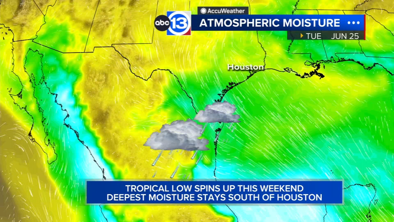
What is happening in the tropics?
We are currently watching the Bay of Campeche as another tropical low spins up this weekend in nearly the same spot Alberto did. Right now there is a 60% chance of development into a tropical depression or storm, but it could send more rain toward Texas, especially South Texas. It does look like the bulk of that moisture will stay mainly southeast of us. The impacts from that system don't look to be near as bad as what we just saw with Alberto. There is also another area off the coasts of Florida and Georgia we're monitoring for development too but that disturbance should move onto land rather quickly which should limit its development. For more on that, head to our Daily Tropical Weather Update page.
13 ALERT RADAR MAPS:
Montgomery/Walker/San Jacinto/Polk/Grimes Counties
Fort Bend/Wharton/Colorado Counties
Have weather tips, videos, and photos?
Send it to ABC13 using the form below. If you have a video or photo to send, terms of use apply. If you don't, just hit 'skip upload' and send the details.