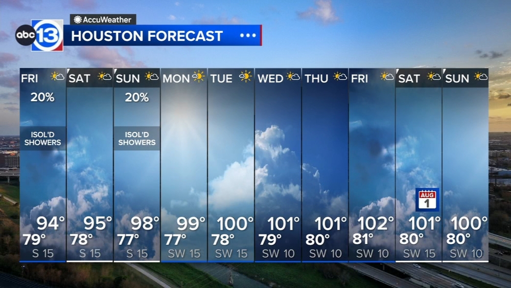
Could another Arctic blast impact Southeast Texas this winter? NOAA scientist weighs in


HOUSTON, Texas (KTRK) -- With this most recent freeze now behind us, many Houstonians are probably wondering if another freeze could impact them this winter.
When it comes to freezes, forecasters typically can't predict them with some amount of certainty more than two weeks out. But guidance from large-scale patterns like the El Niño or polar vortex could show signs of potential changes down the line. This was previously discussed earlier this month when ABC13 Meteorologist Elyse Smith broke down the polar vortex.
A quick refresher - the polar vortex is a phenomenon that develops each winter and keeps extremely cold air locked in place in the Arctic Circle. It's a strong jet stream that develops in the stratosphere, 10 to 30 miles above the Earth's surface, because of a big temperature divide that naturally occurs thanks to the lack of sunlight there in the winter. But the polar vortex can break down and migrate, allowing for that arctic air to spill farther south across portions of North America, Europe, and Asia.
And while the polar vortex did not reach Houston or the state of Texas with this most recent freeze, it did help usher in even colder air to the Great Lakes and Northeast, as well as Canada, northern Asia, and parts of Europe. This is where Dr. Amy Butler, a research scientist with NOAA's Chemical Sciences Laboratory, mentions it could stay a bit cold for the next few weeks because of this initial Arctic event.
"Now, that doesn't mean that it's just going to automatically be really cold for the next four to six weeks. This is very, you know, a slight increase in risk," Butler said.
Butler shared some insight into how long researchers have been monitoring the polar vortex and how often it can send cold air from the Arctic Circle farther south.
"So we've been monitoring the stratosphere for these types of events since about 1958. The first event was detected in Germany from a weather balloon going up and seeing that the temperatures were suddenly much warmer in the stratosphere. And since then, we have measured a lot of these events," Butler said. "They're fairly common. They happen on average about every other winter in the northern hemisphere. And if we look across the entire period back to 1958, there's no change in the frequency of how often these have occurred," Butler said.
On the flip side, the polar vortex isn't just responsible for bitterly cold snaps. It can sometimes lead to record heat, too. Butler mentioned an event in the spring of 2020 where the polar vortex was so strong that the frigid air didn't move away from the North Pole, which, in turn, warmed portions of Siberia to record levels.
But at the end of the day, Butler agrees that the term polar vortex should be used carefully, noting "the role of this vortex is quite removed from the actual weather that's happening."
This means that while the polar vortex can influence certain changes, it's not always the root cause of colder weather in the winter.
For more on this story, follow Elyse Smith on Facebook, Twitter and Instagram.