A summer front brings a chance for strong storms late Saturday

HOUSTON, Texas (KTRK) -- Our hot weather will continue this weekend but a summer front blows in a chance of showers and thunderstorms.
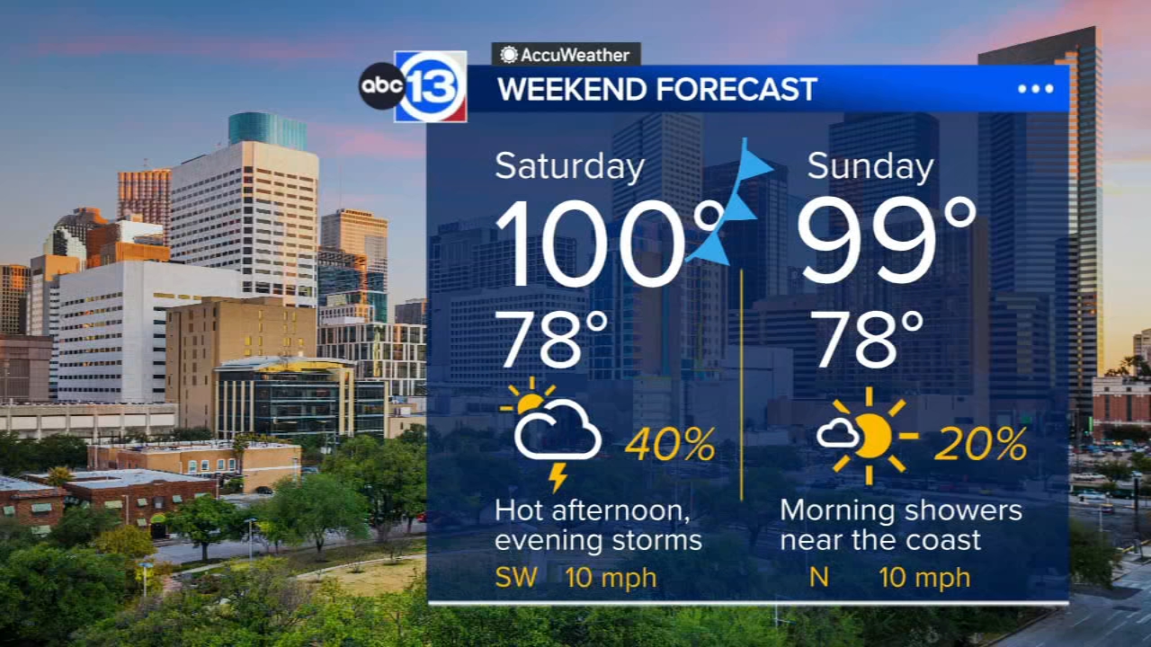
We'll get plenty of sunshine to cook highs up toward 100 in the afternoon. Then the summer front will blow in toward evening to boost rain chances to around 40%.
What should we know about Saturday's rain chance?
The summer storm front will approach Houston in the evening sometime between 5 p.m. and 7 p.m. That's when scattered thunderstorms will start bubbling up. Because it will be so hot, there's also the chance a one or two storms could throw down some strong wind gusts. Models show better chances for storms west of I-45.
Any severe weather of flooding expected this weekend?
Severe weather is possible, but flooding is unlikely. The main concerns will be strong wind gusts reaching severe levels over 60 mph in one or two of the stronger storms. Locally heavy rainfall and lighting are also possible. If you have any plans late Saturday evening into the night, this is something to be aware of that night. And while some of these storms could produce heavy downpours and rainfall rates of 1-3 inches an hour, flooding is not expected at this time.
Will any rain linger into Sunday?
Sunday's rain chance depends on how quickly the front pushes through. For now we think there will be some showers lingering after sunrise, especially south of I-10, but it should move offshore quick enough to where most of the day is rain-free.
What are you tracking in the tropics?
Saharan dust is blowing through the Atlantic with a tropical storm in the Pacific. Visit our Tropical Update page for a more in-depth tropical weather discussion and forecast.
13 ALERT RADAR MAPS:
Southeast Texas
Houston
Harris County
Galveston County
Montgomery/Walker/San Jacinto/Polk/Grimes Counties
Fort Bend/Wharton/Colorado Counties
Brazoria/Matagorda Counties
Have weather tips, videos, and photos?
Send it to ABC13 using the form below. If you have a video or photo to send, terms of use apply. If you don't, just hit 'skip upload' and send the details.