Yes, it's hot, but there's a chance for heat-relieving showers later this week

HOUSTON, Texas (KTRK) -- Record highs will be challenged later this week as a sprawling dome of heat presses on Texas, but we do have a chance for heat-relieving showers by the weekend.
Until then, it's mostly dry with the humidity and heat combo flirting with dangerous levels.
Overnight, temperatures will dip into the mid-to-upper 70s, which is fairly typical for late July. Tuesday afternoon brings more bright sunshine under a partly cloudy sky. The sunshine will help temperatures rise quickly into the mid-upper 90s with an afternoon heat index as high as 110 degrees expected. A Heat Advisory has been issued for all of Southeast Texas from Noon to 7 p.m. Tuesday.
How hot will it get this week?
We expect a few days this week with triple digit heat thanks to that summertime heat dome. Morning lows temperatures will still be in the upper 70s, giving us some time to enjoy the day before the true heat sets in during the afternoon. But by the latter portions of the week, morning lows will be in the low 80s.
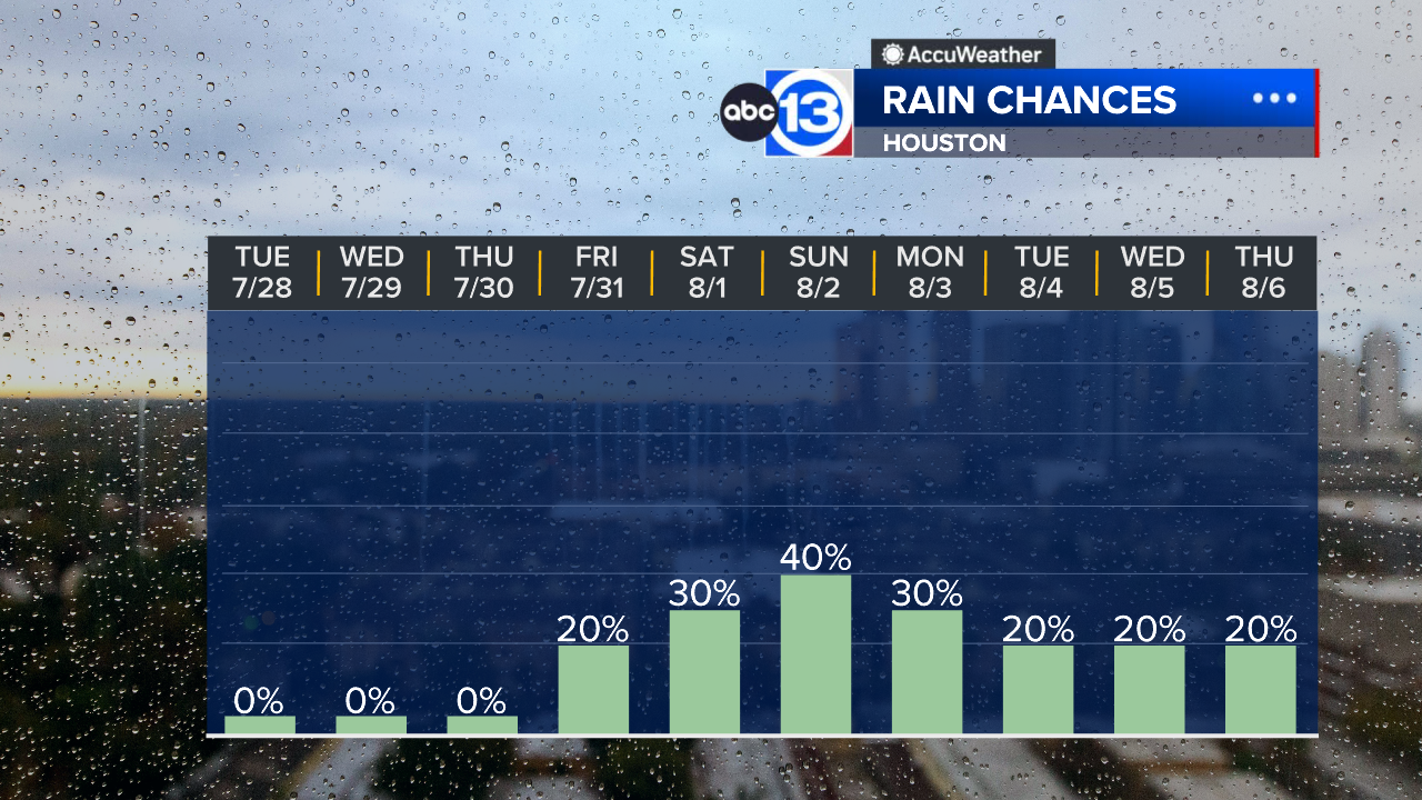
When will the rain chance return?
A summer cool front will get close enough to us by the weekend to warrant at least a 20-30% chance of rain Saturday and 40% on Sunday. And while that front may not bring a refreshing cool down, it could help keep a daily rain chance in the forecast next week as temperatures dip back closer to their seasonal range for the first week of August.
What are you tracking in the tropics?
Saharan dust is blowing through the Atlantic with two hurricanes in the Pacific. Visit our Tropical Update page for a more in-depth tropical weather discussion and forecast.
13 ALERT RADAR MAPS:
Southeast Texas
Houston
Harris County
Galveston County
Montgomery/Walker/San Jacinto/Polk/Grimes Counties
Fort Bend/Wharton/Colorado Counties
Brazoria/Matagorda Counties
Have weather tips, videos, and photos?
Send it to ABC13 using the form below. If you have a video or photo to send, terms of use apply. If you don't, just hit 'skip upload' and send the details.