ABC13 Weather Alert: Tropical Storm Edouard could bring street, flash flooding Tuesday and Wednesday

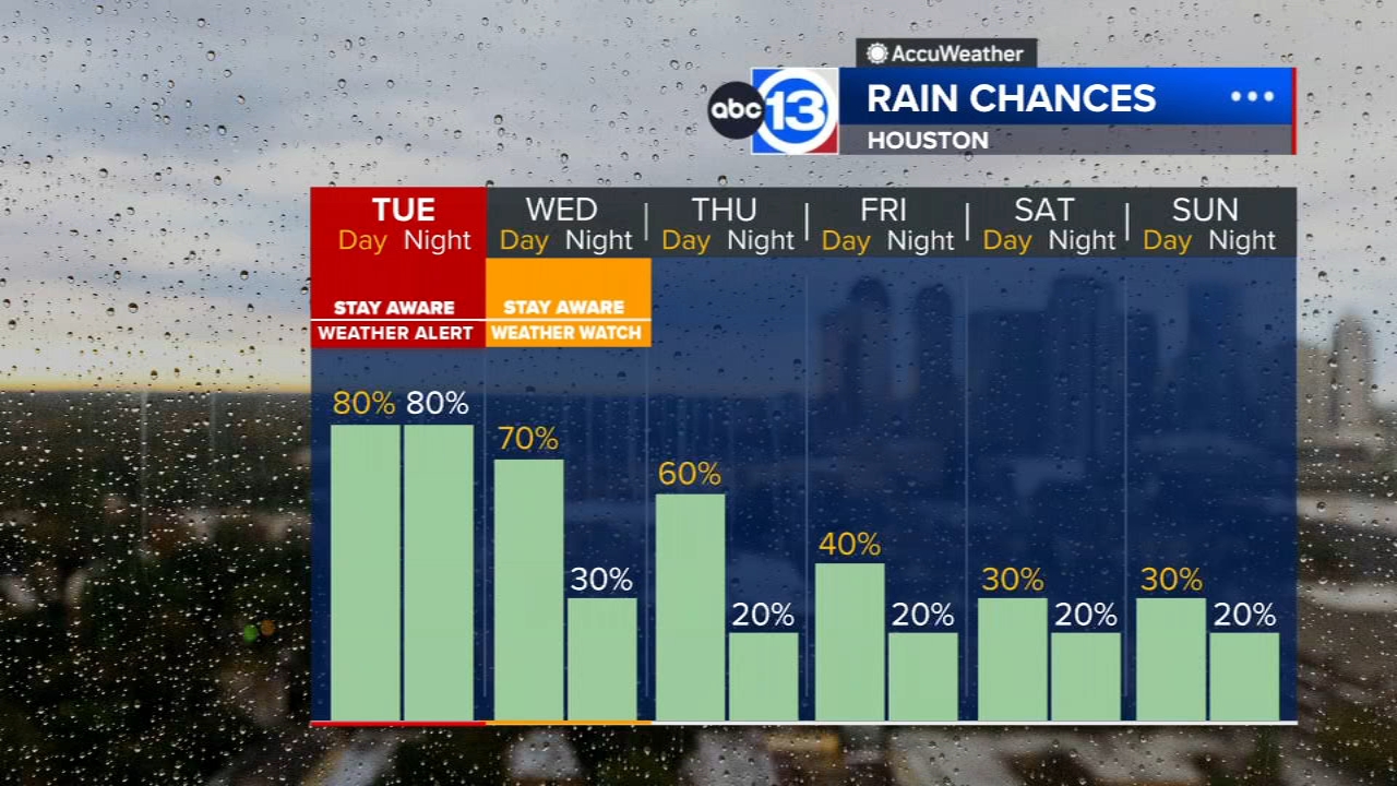
HOUSTON, Texas (KTRK) -- Tropical Storm Edouard has formed in the Gulf with impacts expected in Southeast Texas Tuesday and Wednesday. That's why Tuesday is an ABC13 Weather Alert Day with an ABC13 Weather Watch continuing through Wednesday. Edouard has the potential to bring strong wind gusts and heavy rainfall to parts of Southeast Texas, and a Flood Watch is in effect for the counties most at-risk of encountering those flooding tropical rains.
It's a quiet start to Tuesday with a cloudy sky and mild temperatures in the upper 70s and low 80s. A few showers will begin to approach Southeast Texas from the east as tropical storm Edouard continues to spin closer to the Texas coast. Edouard will make landfall close to Sabine Pass early Tuesday afternoon, bringing showers and storms to Southeast Texas off and on for the rest of the day. Storm chances increase east of I-45 as the core of Edouard moves inland. And there is the possibility for weak tornadoes as well, especially in portions of Liberty and Chambers counties. The drive home, especially late in the evening, could be treacherous for some in the path of Edouard with street and flash flooding expected with the heaviest downpours.
What else should we know about Tropical Storm Edouard?
Tropical Storm Edouard formed on Monday evening and will make landfall somewhere between High Island and Cameron Parish, LA Tuesday afternoon. The main concern with this tropical system will be the risk for street and urban flooding as well as flash flooding Tuesday and into Wednesday. Other tropical storm impacts of strong wind gusts and a minor surge are also possible along the coast along and east of the landfall location. This system will then track through Southeast Texas with the core of the storm likely staying east of I-45, which is also where the greatest impacts will be of any flood risks or strong winds that could lead to localized power outages. From there, we'll still have the lingering circulation overhead norther of Houston on Wednesday morning with the possibility for wrap-around showers and storms that could lead to additional street flooding, this time mainly north of I-10. And while we'll still have some lingering rain chances on Thursday, we do not expect the storm to stall to a point where we'd keep rain in the forecast longer.
What weather alerts are associated with this system?
A Flood Watch is in effect until 7 a.m. Wednesday for Harris, Brazoria, Fort Bend, Galveston, Montgomery, Chambers, Liberty, San Jacinto and Polk counties. Heavy tropical downpours are expected that could lead to street and urban flooding as well as flash flooding at times. Around 3 to 5 inches of rain could fall widespread across the region with the Watch, though isolated totals between 6 to 9 inches of rain are possible too, especially east of I-45. A Tropical Storm Warning is in effect for Chambers County as well as the water offshore from Galveston Island to the Bolivar Peninsula as well as Galveston Bay. Tropical storm force wind gusts up to 70 mph are possible at times in the warned area as well as a high-tide storm surge of 1 to 4 feet above normally dry ground.
What does the rest of the week look like?
Beyond Tuesday and the main tropical-impact day, scattered showers and storms will still be possible through Thursday as any remaining tropical moisture could lead to further rainfall. And depending on how much rain falls Tuesday with additional rain expected Wednesday and Thursday, localized street flooding and flash flooding could occur. It won't be as hot, with highs likely only staying within the low-to-mid 90s day by day. It'll also be quite humid, especially in the morning, with morning low temperatures still in the mid-to-upper 70s all week long.
How about an early outlook for Labor Day Weekend?
At this time, any tropical mischief related to Edouard should be out of here. We'll be back to a warm and calm weather pattern, which means hot afternoons with highs in the mid-upper 90s and the chance for a few pop-up showers and storms with the sea breeze Saturday through Monday.
What else are you tracking in the tropics?
Aside from Edouard, we are also tracking 3 tropical systems in the Pacific. For a more in-depth discussion on what's happening in the tropics, visit our Daily Tropical Update page.

13 ALERT RADAR MAPS:
Southeast Texas
Houston
Harris County
Galveston County
Montgomery/Walker/San Jacinto/Polk/Grimes Counties
Fort Bend/Wharton/Colorado Counties
Brazoria/Matagorda Counties
Have weather tips, videos, and photos?
Send it to ABC13 using the form below. If you have a video or photo to send, terms of use apply. If you don't, just hit 'skip upload' and send the details.