Triple-digit heat wave begins in Houston but relief could come late next week

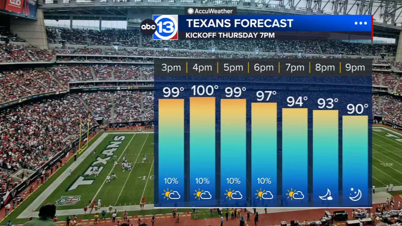
HOUSTON, Texas (KTRK) -- The hottest and driest stretch of summer is upon us, and all of Southeast Texas is under a Heat Advisory from noon Thursday to 7 p.m. Friday. Heat index values will peak between 105 to 110 degrees in the late afternoon, increasing the threat for heat-related illness. For those tailgating ahead of the Texans preseason game, make sure you stay well-hydrated as you spend time on the hot parking lot.
Overnight we expect lows around 80 in Houston with mid 70s outside of the urban heat island. Temperatures Thursday afternoon will climb to around 100 degrees. During the peak heat of the day, there is a 10% chance of a stray storm popping up over or near Houston. Your chance of getting rain is only 10%.
Are we going to be dealing with triple-digit heat all week?
Yep. High temperatures will likely hit 100 or higher every day left this week...and at least half of next week, too. Humidity levels will also increase by the weekend, pushing the heat index higher.
How hot will it get this weekend?
Unfortunately, it looks like this weekend could bring the hottest weather of the entire heat wave. For now we have high temperatures peaking around 102 degrees both days. The heat index could also be dangerously high in the afternoon with it feeling like 110 degrees outside at times.
Is there any rain in the forecast?
Yes, but they are slim. We've got a 10% chance for rain Thursday, Friday, and Saturday. Next week we have a 20% chance of rain on Friday and Saturday as the heat dome slides back to the west and moisture levels rise. If we gain confidence that the heat dome will slide fairly far to our west, then our rain chances will go higher.
What should I know about the potential for a flash drought?
First, it's important to understand what a flash drought is. This is what we call it when a drought suddenly develops over 1 or 2 weeks of hot, dry weather instead of the usual 1 or 2 months it takes a more typical drought to develop. This means if you want to keep drought-sensitive vegetation alive, you will need to provide the water. You might also consider providing low amounts of water to your home's foundation to help stabilize the soil moisture and prevent movement in the ground that supports your foundation. This is especially important if your soil is mostly composed of clay.
Are there any signs that this hot, dry pattern will break any time soon?
We see a glimmer of hope that the pattern could budge some toward the end of next week, which is why we have an "optimistic" high of "just" 99 and a 20% chance of rain in the forecast by Friday.
What's happening in the tropics?
Lala continues to move away from Hawaii as more Pacific disturbances threaten to develop. Meanwhile in the Atlantic, we are watching some tropical waves and Saharan dust emerging from Africa. For a more in-depth discussion on what's happening in the tropics, visit our Daily Tropical Update page.

13 ALERT RADAR MAPS:
Southeast Texas
Houston
Harris County
Galveston County
Montgomery/Walker/San Jacinto/Polk/Grimes Counties
Fort Bend/Wharton/Colorado Counties
Brazoria/Matagorda Counties
Have weather tips, videos, and photos?
Send it to ABC13 using the form below. If you have a video or photo to send, terms of use apply. If you don't, just hit 'skip upload' and send the details.