Tropical Storm Bertha slowly churns near Florida, Extreme Heat Warning issued for Southeast Texas


HOUSTON, Texas (KTRK) -- Extreme heat, severe storms, and Tropical Storm Bertha could all impact Houston over the next couple of days, and our weather team has issued an ABC13 Weather Watch for both Wednesday and Thursday.
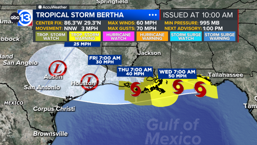
Before we get a chance of rain from Bertha, we have to make it through a dangerously hot afternoon Wednesday. The heat dome steering Bertha toward Louisiana is also pushing our highs to near 100 today and well over 100 tomorrow. A Heat Advisory is in effect for all of Southeast Texas until 8 p.m. today. A Heat Advisory is issued when the heat index is expected to top 108.
New this afternoon, the National Weather Service has also issued an Extreme Heat Warning for tomorrow as the air temperature peaks near 105 degrees with a heat index near 115 degrees. This is not our typical summer heat, and all precautions should be taken to avoid heat exhaustion and heat stroke on Wednesday for those who have to be outside. Stay well hydrated, take frequent breaks in the shade if you have to work outside, and wear light colored clothing.
No rain is expected today, but there is a small chance for big storms late Wednesday after temperatures peak near 104 degrees in Houston. Some of these storms could pack severe wind gusts over 60 mph.
When could we get rain from Tropical Storm Bertha?
A band of moisture swirling around Bertha's circulation could impact us Wednesday evening. After that, there is a chance of scattered tropical downpours Thursday and to a lesser extent Friday from whatever remains of Bertha's moisture and circulation. At this time we are expecting an inch or less of rain, if you get any at all.
What should we expect for the weekend?
Any moisture from Tropical Storm Bertha will be long gone, so rain chances will hover near 10% as highs heat back into the upper 90s.
What else are you tracking in the tropics?
Our focus right now is on the Gulf and Bertha as there are no other tropical threats at this time. Visit our Tropical Update page for a more in-depth tropical weather discussion and forecast.
13 ALERT RADAR MAPS:
Southeast Texas
Houston
Harris County
Galveston County
Montgomery/Walker/San Jacinto/Polk/Grimes Counties
Fort Bend/Wharton/Colorado Counties
Brazoria/Matagorda Counties
Have weather tips, videos, and photos?
Send it to ABC13 using the form below. If you have a video or photo to send, terms of use apply. If you don't, just hit 'skip upload' and send the details.