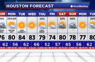
Rain and storm chances increased for Houston


After a near perfect weekend, we are in for a change. Steady south winds will continue to transport in moisture, so it's going to feel a lot more humid today. That moisture along with daytime heating and a passing disturbance will give us scattered showers and storms.
Storms are coming at us from two directions, with a warm front from the south, and a storm complex to the north. Because of the strength of the storm complex coming in from the north, a Severe Thunderstorm Watch may be issued for the Houston area as it approaches.
The worst of the storms are expected to miss Houston, heading off to the east. But the back edge of this line of storms will likely move into Houston during the lunch hour. As it collides with the warm front, we can expect a stormy afternoon from Houston eastward.
Rain chances will go down a bit on Tuesday and Wednesday but shoot back up towards the end of the week.
Another cool front will get close enough to us to spark more storms Thursday through Sunday. Unfortunately, that front won't go through so the very warm, humid weather will last the next seven days at least.