

Harris County adjusts map that incorrectly showed flood prevention projects as complete


KINGWOOD, Texas (KTRK) -- Some Kingwood neighbors believe a new Harris County flood map is misleading and are worried about what it could mean for future flood mitigation projects.
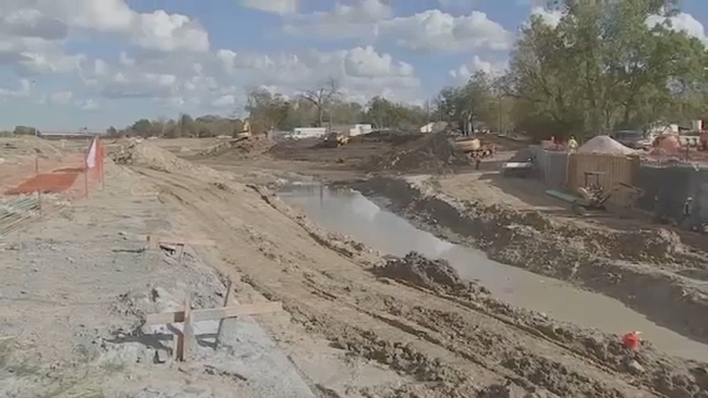
For Kingwood neighbors living near the Taylor Gully, heavy storms caused substantial flooding in 2019.
"It was somewhat traumatic for a lot of people, including ourselves," Abel Vera recalled.
Six years ago, Vera's home got more than 20 inches of water inside. Just after he rebuilt, Tropical Storm Imelda sent even more water inside.
"That time, we ended up with 33 inches of water in our home," Vera recalled.
To help Abel and his neighbors, flood mitigation projects were planned: one to hold water and send it to a drainage system and an improved gully to move the water -- two projects Abel is waiting on.
"The culvert that they installed has never been touched," Abel explained. "The gully has never been touched."
Despite the lack of action, to Vera's disbelief, a new Harris County Flood Control District map says both projects are complete.
"'What are they saying they've completed?' I guess my question would be to them," Abel said.
It's a question Bob Rehak wants to know as well. The Kingwood man runs Reduce Flooding Now, a website that tracks flood mitigation projects. When he saw the county's new map, he couldn't believe it.
"They're giving people the wrong impression about where these things stand," Rehak said. "They say they want to be more transparent, but they're actually being less transparent."
SEE PREVIOUS REPORT: Harris County prepares to ramp up flood project maintenance following Prop A approval
Rehak found five projects listed as either complete or in progress that don't have any construction taking place.
The website said the map shows where flood reduction projects are taking place across the county and whether if they're complete or active.
ABC13 asked the flood control district about the map and the projects Rehak found.
A spokesperson told us that while construction may not be underway, an area may be complete because a certain portion of the whole project is done. Eyewitness News was told they're working to update the map to make it clearer.
After the story ran on Eyewitness News Tuesday, an agency spokesperson told ABC13 that it had removed the complete projects from the map to clear any confusion.
"My concern is that if somebody in Washington, where they're looking to cut cost right now, saw this, they might think, 'Why should I fund this project? It's complete,'" Rehak explained.
It's a worry Vera has, too, because after flooding twice, he's hoping work does take place on two projects to protect his home.
"It's just somewhat of a dishonest thing to do to the community," Vera said. "I don't stand behind that."
The map comes at a time when the commissioners' court has been pressing the flood control district for more information. On Tuesday, ABC13 reached out to a couple of the commissioners who have been vocal about flood mitigation projects, but we have not heard back.
For updates on this story, follow Nick Natario on Facebook, X and Instagram.


