ABC13 Weather Watch: Tropical Storm Bertha set to make landfall in Southeast Texas Thursday

HOUSTON, Texas (KTRK) -- Extreme heat, severe storms, and Tropical Storm Bertha will all impact Houston today and tomorrow, and our weather team has issued an ABC13 Weather Watch through Thursday.
Before we get a chance of rain from Bertha, we have to make it through these dangerously hot temperatures. The heat dome steering Bertha toward Texas is also pushing our highs into extremely hot territory, even by our standards. This record heat is made worse by the tropical air pushing heat index values over 115 degrees. The National Weather Service has an Extreme Heat Warning in effect for all of Southeast Texas until 8 p.m. This is not our typical summer heat, and all precautions should be taken to avoid heat exhaustion and heat stroke today for those who have to be outside. Stay well hydrated, take frequent breaks in the shade if you have to work outside, and wear light colored clothing.
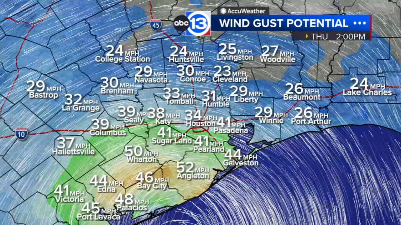
A band of moist air rotating around Bertha is also producing scattered thunderstorms that could pack severe wind gusts over 60 mph in our part of Texas. These storms will quickly blow in from the northeast and could knock out the power in some neighborhoods.
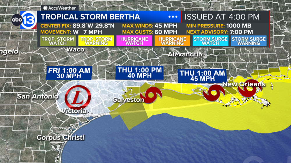
A Tropical Storm Watch has also been issued along the coast by the National Hurricane Center. Coastal sections of Brazoria and Galveston County as well as all of Chambers County are included. This means that tropical storm condition are possible as Bertha moves through tomorrow.
At this time we think disruptions and impacts form Bertha will be minimal. It should be a breezy day with scattered showers and thunderstorms blowing through in the afternoon and evening. Where it does rain, totals will generally run less than an inch, but higher totals are possible south of Houston closer to Matagorda Bay. The winds could gust around 40-50 mph along our coast, with wind gusts up to 40 mph possible in Houston.
How long will Bertha stick around?
We will be mostly done with Bertha by Friday morning.
What should we expect for the weekend?
Any moisture from Tropical Storm Bertha will be long gone, so rain chances will hover near 10% as highs heat back into the upper 90s. Multiple triple-digit-days are likely next week.
What else are you tracking in the tropics?
Our focus right now is on the Gulf and Bertha as there are no other tropical threats at this time. Visit our Tropical Update page for a more in-depth tropical weather discussion and forecast.
13 ALERT RADAR MAPS:
Southeast Texas
Houston
Harris County
Galveston County
Montgomery/Walker/San Jacinto/Polk/Grimes Counties
Fort Bend/Wharton/Colorado Counties
Brazoria/Matagorda Counties
Have weather tips, videos, and photos?
Send it to ABC13 using the form below. If you have a video or photo to send, terms of use apply. If you don't, just hit 'skip upload' and send the details.