Scattered downpours blowing through Houston this afternoon
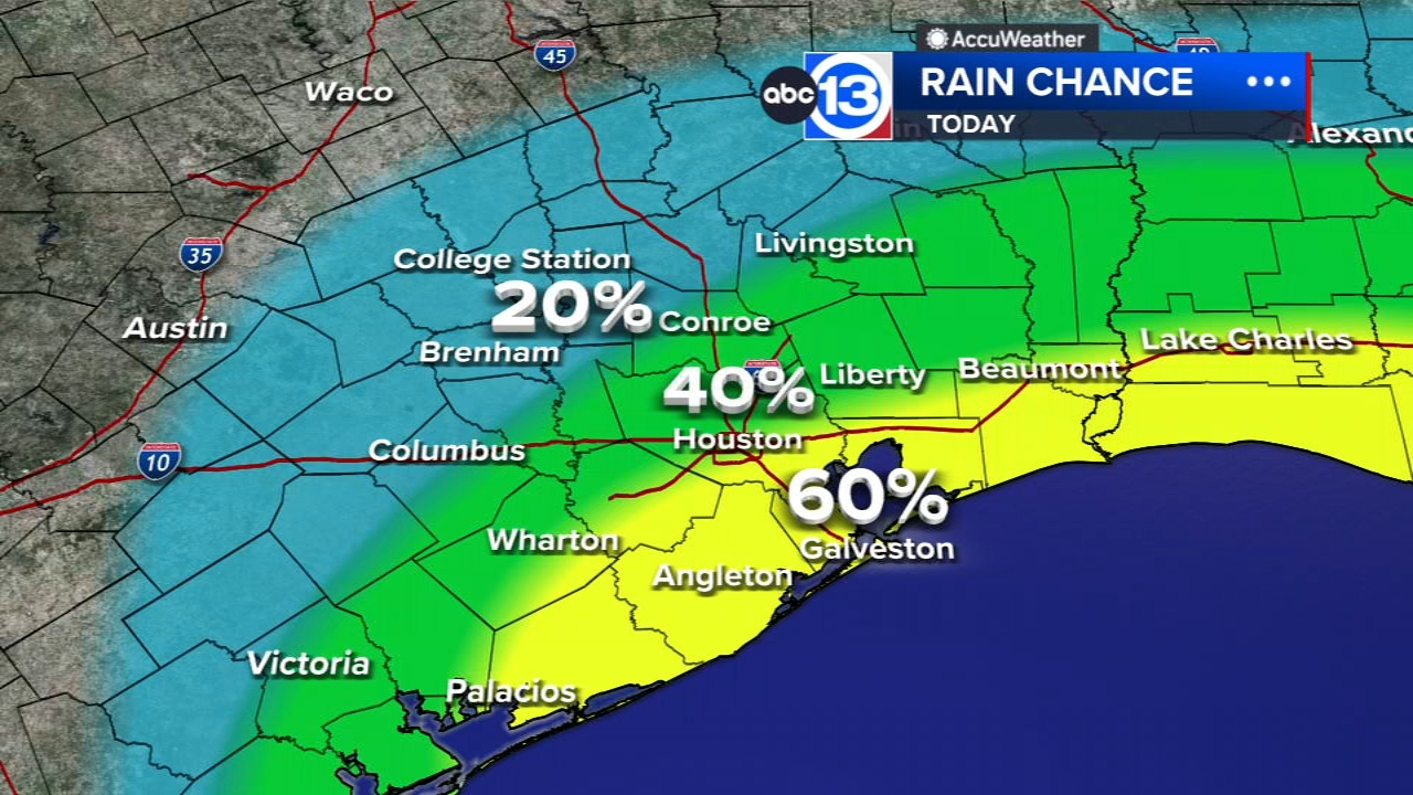

HOUSTON, Texas (KTRK) -- Another round of scattered downpours is rumbling in from the Gulf with tropical air still over Southeast Texas.
Those scattered showers and thunderstorms will spread north of I-10 as the afternoon goes on. Widespread rain clouds will keep temperatures in check. Highs will range from the upper 80s to the mid 90s across the region. If you get a heavy rain shower, you temperature will dip toward 80 degrees. A quick inch or two of rain is possible in the heaviest storms. Wind gusts over 40 mph and frequent lightning are also expected in the stronger storms. Your chance of rain is 40% in Houston but 60% in the coastal counties. All the rain should dissipate sometime between 7 p.m. and 8 p.m.
What are those rain chances for the rest of the week?
After today, we have a 30% chance of rain for Friday and the weekend.
Are anymore triple-digit temperatures in the forecast?
Nope! But...temperatures will stay above normal for the next 10 days. That means afternoon high temperatures in the low-to-mid 90s, and when you factor in the humidity, it'll definitely feel like the triple digits with a heat index above 100.
Are you seeing any signs of a fall front coming this way?
Not over the next 10 days, but it's possible a fall-ish front could slip in during the last 10 days of September.
What are you tracking in the tropics?
Norbert has formed in the Pacific, meanwhile the Atlantic remains quiet here at the peak of hurricane season. For a more in-depth discussion on what's happening in the tropics, visit our Daily Tropical Update page.
Top Stories


13 ALERT RADAR MAPS:
Southeast Texas
Houston
Harris County
Galveston County
Montgomery/Walker/San Jacinto/Polk/Grimes Counties
Fort Bend/Wharton/Colorado Counties
Brazoria/Matagorda Counties
Have weather tips, videos, and photos?
Send it to ABC13 using the form below. If you have a video or photo to send, terms of use apply. If you don't, just hit 'skip upload' and send the details.