A few showers and t-storms possible this afternoon, another round possible on Friday

HOUSTON, Texas (KTRK) -- A few showers and storms are possible this afternoon as moisture lingers from yesterday's widespread downpours.
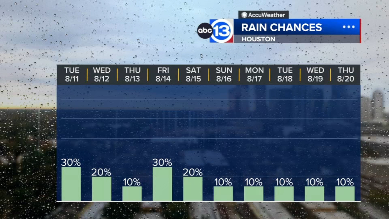
There's only a 30% chance you'll get a shower or thunderstorm today, but where they pop up the rain could get heavy and drop up to an inch of rain. Lightning is also possible in the strongest storms. Temperatures will peak in the mid 90s, near the average high of 96.
What can we expect for the rest of the work week?
Rain chances will stay on the low side, ranging from 10-30%. The two days with the highest odds of a few showers and storms are today and Friday. Otherwise, expect warm mornings and hot afternoons with afternoon highs reaching into the upper 90s by the end of the week.
What about the weekend with the Pride Houston Parade?
At this time it looks like the weekend will also be not as stormy and wet, but definitely hot. A heat dome will begin to settle in across the region heading into the weekend, likely giving highs a boost into the upper 90s. The heat index both Saturday and Sunday afternoon could peak near 107 degrees.
What's happening in the tropics?
The tropical wave train off the west coast of Africa is beginning to take shape. There are two regions to watch for potential tropical development over the next 7 days with one wave currently in the mid-Atlantic and another just entering it. For a more in-depth discussion on what's happening in the tropics, visit our Daily Tropical Update page.
13 ALERT RADAR MAPS:
Southeast Texas
Houston
Harris County
Galveston County
Montgomery/Walker/San Jacinto/Polk/Grimes Counties
Fort Bend/Wharton/Colorado Counties
Brazoria/Matagorda Counties
Have weather tips, videos, and photos?
Send it to ABC13 using the form below. If you have a video or photo to send, terms of use apply. If you don't, just hit 'skip upload' and send the details.