Tropical Storm Bertha slowly churns near Florida, Heat Advisory issued for Tuesday


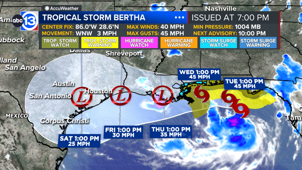
HOUSTON, Texas (KTRK) -- Tropical Storm Bertha formed in the eastern Gulf Monday evening and is forecast to slowly push closer to Louisiana over the next 48 hours. Eventually the system could bring us some scattered tropical downpours late in the week, but at this time we don't expect anything significant.
While the eastern Gulf is active, the western Gulf is quiet for now. A heat dome in the upper atmosphere will bring us our hottest week so far this summer, and a Heat Advisory is in effect for all of Southeast Texas on Tuesday. That's issued when the heat index is expected to top 108.
Temperatures overnight will cool down into the seasonal mid 70s, then all the sunshine will push highs toward 100 degrees in the afternoon. No rain is expected on Tuesday, but a small chance is possible late Wednesday when it gets even hotter.
When could we get rain from Tropical Storm Bertha?
If we get any rain from Bertha, it would likely be in the Thursday to Friday timeframe. At this time we are expecting less than an inch of rain, if any at all.
What should we expect for the weekend?
Any moisture from Tropical Storm Bertha should be gone, so rain chances will drop to 20% or less with highs back in the upper 90s.
What else are you tracking in the tropics?
Our focus right now is on the Gulf and Bertha as there are no other tropical threats at this time. Visit our Tropical Update page for a more in-depth tropical weather discussion and forecast.
13 ALERT RADAR MAPS:
Southeast Texas
Houston
Harris County
Galveston County
Montgomery/Walker/San Jacinto/Polk/Grimes Counties
Fort Bend/Wharton/Colorado Counties
Brazoria/Matagorda Counties
Have weather tips, videos, and photos?
Send it to ABC13 using the form below. If you have a video or photo to send, terms of use apply. If you don't, just hit 'skip upload' and send the details.