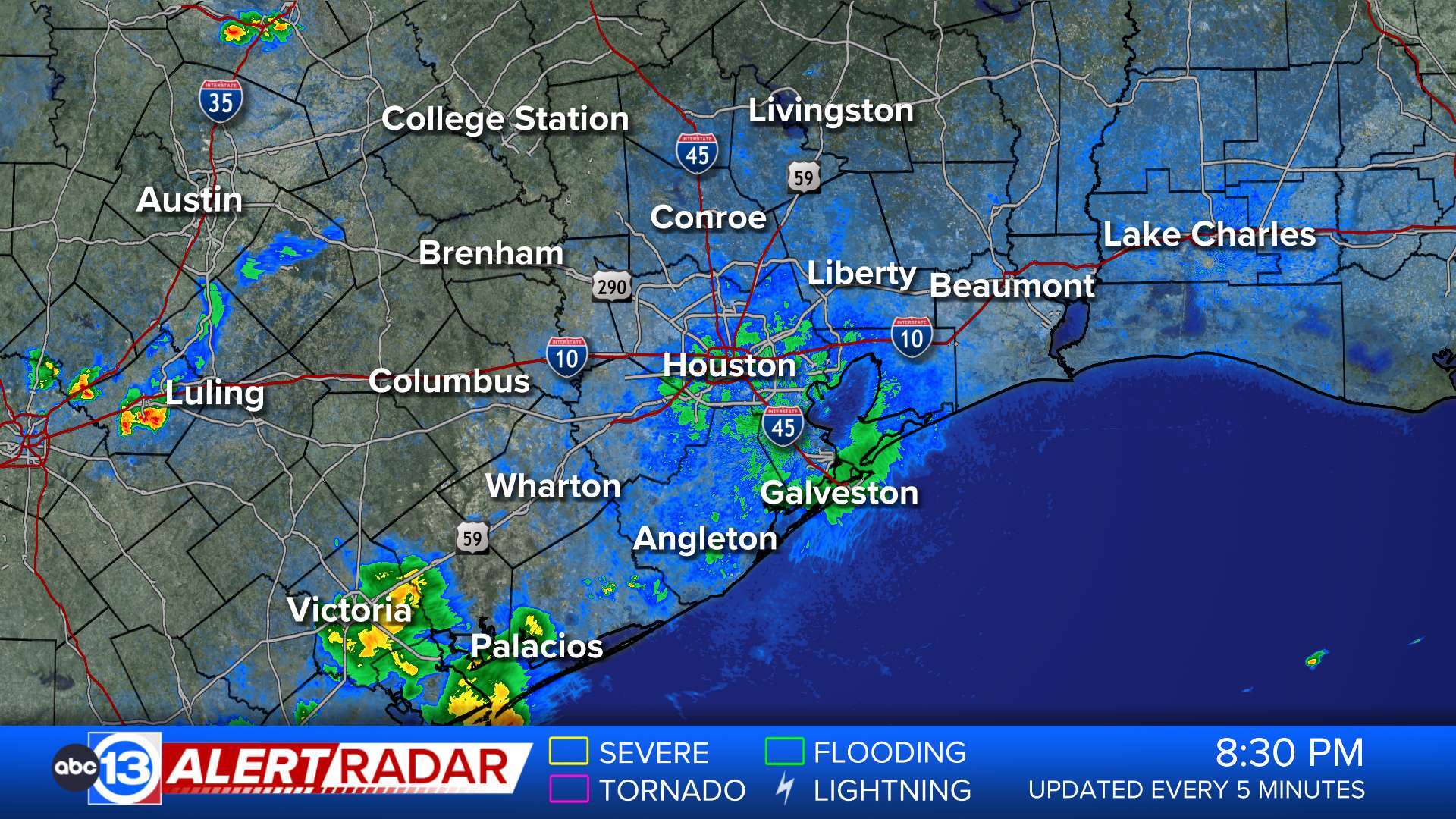
ABC13 Houston Weather Radar for Southeast Texas

- Flood Warning
* WHAT...Small stream flooding caused by excessive rainfall continues. * WHERE...A portion of southeast Texas, including the following counties, Brazos and Grimes. * WHEN...Until 700 PM CDT Monday. * IMPACTS...Flooding of rivers, creeks, streams, and other low-lying and flood-prone locations is imminent or occurring. Streams continue to rise due to excess runoff from earlier rainfall. * ADDITIONAL DETAILS... - At 830 PM CDT, Department of Transportation reported that water from the Navasota River has begun flooding the bridge at Highway 30 and has been closed. - Some locations that will experience flooding include... mainly rural areas of East Central Brazos and Northwestern Grimes Counties - http://www.weather.gov/safety/floodMore
- Flood Warning
...The Flood Warning continues for the following rivers in Texas... Menard Creek near Rye affecting Hardin, Polk and Liberty Counties. Bedias Creek near Madisonville affecting Walker and Madison Counties. San Jacinto River near Sheldon affecting Harris County. West Fork San Jacinto near Humble affecting Harris and Montgomery Counties. Navasota River near Normangee affecting Grimes, Madison and Brazos Counties. Trinity River near Crockett affecting Walker, Madison, Houston and Trinity Counties. Trinity River near Romayor affecting Polk, Liberty and San Jacinto Counties. Trinity River at Liberty affecting Liberty County. Trinity River near Goodrich affecting Polk, Liberty and San Jacinto Counties. Trinity River near Moss Bluff affecting Chambers and Liberty Counties. Trinity River at Riverside affecting Walker, Trinity, Polk and San Jacinto Counties. ...The Flood Warning is extended for the following rivers in Texas... East Fork San Jacinto near New Caney affecting Harris, Montgomery and Liberty Counties. Lake Creek at Sendera Ranch Road affecting Montgomery County. For the Trinity River...including Crockett, Riverside, Romayor, Goodrich, Liberty, Moss Bluff...Major flooding is forecast. For the Menard Creek...including Rye...Moderate flooding is forecast. For the East Fork San Jacinto River...including Cleveland, New Caney...Moderate flooding is forecast. For the West Fork San Jacinto River...including Porter, Sendera Ranch Road, Conroe, Humble, Sheldon...Major flooding is forecast. For the Navasota River...including Normangee...Moderate flooding is forecast. * WHAT...Minor flooding is occurring and minor flooding is forecast. * WHERE...Lake Creek at Sendera Ranch Road. * WHEN...Until late tomorrow morning. * ADDITIONAL DETAILS... - At 7:45 PM CDT Sunday the stage was 138.1 feet. - Bankfull stage is 129.0 feet. - Recent Activity...The maximum river stage in the 24 hours ending at 7:45 PM CDT Sunday was 138.8 feet. - Forecast...The river is expected to fall below flood stage late this evening and continue falling to 130.5 feet Friday evening. - Flood stage is 138.0 feet. - Flood History...This crest compares to a previous crest of 138.1 feet on 12/06/2016. - http://www.weather.gov/safety/floodMore
- Flood Warning
...The Flood Warning continues for the following rivers in Texas... Menard Creek near Rye affecting Hardin, Polk and Liberty Counties. Bedias Creek near Madisonville affecting Walker and Madison Counties. San Jacinto River near Sheldon affecting Harris County. West Fork San Jacinto near Humble affecting Harris and Montgomery Counties. Navasota River near Normangee affecting Grimes, Madison and Brazos Counties. Trinity River near Crockett affecting Walker, Madison, Houston and Trinity Counties. Trinity River near Romayor affecting Polk, Liberty and San Jacinto Counties. Trinity River at Liberty affecting Liberty County. Trinity River near Goodrich affecting Polk, Liberty and San Jacinto Counties. Trinity River near Moss Bluff affecting Chambers and Liberty Counties. Trinity River at Riverside affecting Walker, Trinity, Polk and San Jacinto Counties. ...The Flood Warning is extended for the following rivers in Texas... East Fork San Jacinto near New Caney affecting Harris, Montgomery and Liberty Counties. Lake Creek at Sendera Ranch Road affecting Montgomery County. For the Trinity River...including Crockett, Riverside, Romayor, Goodrich, Liberty, Moss Bluff...Major flooding is forecast. For the Menard Creek...including Rye...Moderate flooding is forecast. For the East Fork San Jacinto River...including Cleveland, New Caney...Moderate flooding is forecast. For the West Fork San Jacinto River...including Porter, Sendera Ranch Road, Conroe, Humble, Sheldon...Major flooding is forecast. For the Navasota River...including Normangee...Moderate flooding is forecast. * WHAT...Moderate flooding is occurring and moderate flooding is forecast. * WHERE...East Fork San Jacinto near New Caney. * WHEN...Until late Wednesday evening. * IMPACTS...At 68.5 feet, Moderate lowland flooding continues with water over the lowest slab elevations of buildings on the downstream side near the gauge, as well as several hunting camps along the left bank approximately 2 miles downstream of the gauge begin to take on water. Widespread flooding continues in the vicinity of the gauge and in the right floodplain with many roads including FM 1485 inundated and closed. * ADDITIONAL DETAILS... - At 8:00 PM CDT Sunday the stage was 67.5 feet. - Bankfull stage is 54.5 feet. - Recent Activity...The maximum river stage in the 24 hours ending at 8:00 PM CDT Sunday was 71.0 feet. - Forecast...The river is expected to fall below flood stage late Wednesday morning and continue falling to 52.0 feet Friday evening. - Flood stage is 58.0 feet. - Flood History...This crest compares to a previous crest of 67.7 feet on 05/19/1989. - http://www.weather.gov/safety/floodMore
- Flood Warning
...The Flood Warning continues for the following rivers in Texas... Menard Creek near Rye affecting Hardin, Polk and Liberty Counties. Bedias Creek near Madisonville affecting Walker and Madison Counties. San Jacinto River near Sheldon affecting Harris County. West Fork San Jacinto near Humble affecting Harris and Montgomery Counties. Navasota River near Normangee affecting Grimes, Madison and Brazos Counties. Trinity River near Crockett affecting Walker, Madison, Houston and Trinity Counties. Trinity River near Romayor affecting Polk, Liberty and San Jacinto Counties. Trinity River at Liberty affecting Liberty County. Trinity River near Goodrich affecting Polk, Liberty and San Jacinto Counties. Trinity River near Moss Bluff affecting Chambers and Liberty Counties. Trinity River at Riverside affecting Walker, Trinity, Polk and San Jacinto Counties. ...The Flood Warning is extended for the following rivers in Texas... East Fork San Jacinto near New Caney affecting Harris, Montgomery and Liberty Counties. Lake Creek at Sendera Ranch Road affecting Montgomery County. For the Trinity River...including Crockett, Riverside, Romayor, Goodrich, Liberty, Moss Bluff...Major flooding is forecast. For the Menard Creek...including Rye...Moderate flooding is forecast. For the East Fork San Jacinto River...including Cleveland, New Caney...Moderate flooding is forecast. For the West Fork San Jacinto River...including Porter, Sendera Ranch Road, Conroe, Humble, Sheldon...Major flooding is forecast. For the Navasota River...including Normangee...Moderate flooding is forecast. * WHAT...Major flooding is occurring and major flooding is forecast. * WHERE...San Jacinto River near Sheldon. * WHEN...Until Thursday morning. * IMPACTS...At 15.0 feet, Major lowland flooding begins. * ADDITIONAL DETAILS... - At 7:15 PM CDT Sunday the stage was 16.2 feet. - Bankfull stage is 8.0 feet. - Recent Activity...The maximum river stage in the 24 hours ending at 7:15 PM CDT Sunday was 19.0 feet. - Forecast...The river is expected to fall below flood stage Wednesday evening and continue falling to 7.5 feet Friday evening. - Flood stage is 10.0 feet. - Flood History...This crest compares to a previous crest of 16.0 feet on 11/07/2002. - http://www.weather.gov/safety/floodMore
- Flood Warning
...The Flood Warning continues for the following rivers in Texas... Menard Creek near Rye affecting Hardin, Polk and Liberty Counties. Bedias Creek near Madisonville affecting Walker and Madison Counties. San Jacinto River near Sheldon affecting Harris County. West Fork San Jacinto near Humble affecting Harris and Montgomery Counties. Navasota River near Normangee affecting Grimes, Madison and Brazos Counties. Trinity River near Crockett affecting Walker, Madison, Houston and Trinity Counties. Trinity River near Romayor affecting Polk, Liberty and San Jacinto Counties. Trinity River at Liberty affecting Liberty County. Trinity River near Goodrich affecting Polk, Liberty and San Jacinto Counties. Trinity River near Moss Bluff affecting Chambers and Liberty Counties. Trinity River at Riverside affecting Walker, Trinity, Polk and San Jacinto Counties. ...The Flood Warning is extended for the following rivers in Texas... East Fork San Jacinto near New Caney affecting Harris, Montgomery and Liberty Counties. Lake Creek at Sendera Ranch Road affecting Montgomery County. For the Trinity River...including Crockett, Riverside, Romayor, Goodrich, Liberty, Moss Bluff...Major flooding is forecast. For the Menard Creek...including Rye...Moderate flooding is forecast. For the East Fork San Jacinto River...including Cleveland, New Caney...Moderate flooding is forecast. For the West Fork San Jacinto River...including Porter, Sendera Ranch Road, Conroe, Humble, Sheldon...Major flooding is forecast. For the Navasota River...including Normangee...Moderate flooding is forecast. * WHAT...Major flooding is occurring and major flooding is forecast. * WHERE...West Fork San Jacinto near Humble. * WHEN...Until late Thursday morning. * IMPACTS...At 55.2 feet, Major lowland flooding continues with up to 6 inches of water is over the 800 block Hamblen Road adjacent to the Kingwood Cove Country Club Golf Course with many homes in the Bellau Woods and Treasure Cove subdivision are flooded. * ADDITIONAL DETAILS... - At 7:45 PM CDT Sunday the stage was 55.2 feet. - Bankfull stage is 15.0 feet. - Recent Activity...The maximum river stage in the 24 hours ending at 7:45 PM CDT Sunday was 58.0 feet. - Forecast...The river is expected to fall below flood stage late Wednesday evening and continue falling to 48.3 feet Friday evening. - Flood stage is 49.3 feet. - Flood History...This crest compares to a previous crest of 55.3 feet on 06/10/2001. - http://www.weather.gov/safety/floodMore
- Flood Warning
...The Flood Warning continues for the following rivers in Texas... Menard Creek near Rye affecting Hardin, Polk and Liberty Counties. Bedias Creek near Madisonville affecting Walker and Madison Counties. San Jacinto River near Sheldon affecting Harris County. West Fork San Jacinto near Humble affecting Harris and Montgomery Counties. Navasota River near Normangee affecting Grimes, Madison and Brazos Counties. Trinity River near Crockett affecting Walker, Madison, Houston and Trinity Counties. Trinity River near Romayor affecting Polk, Liberty and San Jacinto Counties. Trinity River at Liberty affecting Liberty County. Trinity River near Goodrich affecting Polk, Liberty and San Jacinto Counties. Trinity River near Moss Bluff affecting Chambers and Liberty Counties. Trinity River at Riverside affecting Walker, Trinity, Polk and San Jacinto Counties. ...The Flood Warning is extended for the following rivers in Texas... East Fork San Jacinto near New Caney affecting Harris, Montgomery and Liberty Counties. Lake Creek at Sendera Ranch Road affecting Montgomery County. For the Trinity River...including Crockett, Riverside, Romayor, Goodrich, Liberty, Moss Bluff...Major flooding is forecast. For the Menard Creek...including Rye...Moderate flooding is forecast. For the East Fork San Jacinto River...including Cleveland, New Caney...Moderate flooding is forecast. For the West Fork San Jacinto River...including Porter, Sendera Ranch Road, Conroe, Humble, Sheldon...Major flooding is forecast. For the Navasota River...including Normangee...Moderate flooding is forecast. * WHAT...Moderate flooding is occurring and moderate flooding is forecast. This approaches the flood of record. * WHERE...Trinity River near Romayor. * WHEN...Until further notice. * IMPACTS...At 42.0 feet, Major lowland flooding begins with widespread innundation of the flood plain in the vicinity of the gage. Numerous head of livestock are threatened if not already removed from the flood plain. Downstream communities in Liberty should prepare for possible flooding. * ADDITIONAL DETAILS... - At 7:30 PM CDT Sunday the stage was 41.8 feet. - Bankfull stage is 30.0 feet. - Recent Activity...The maximum river stage in the 24 hours ending at 7:30 PM CDT Sunday was 42.0 feet. - Forecast...The river is expected to remain steady above flood stage at 41.5 feet. - Flood stage is 40.0 feet. - Flood History...This crest compares to a previous crest of 41.6 feet on 05/21/1990. - http://www.weather.gov/safety/floodMore
- Flood Warning
...The Flood Warning continues for the following rivers in Texas... Menard Creek near Rye affecting Hardin, Polk and Liberty Counties. Bedias Creek near Madisonville affecting Walker and Madison Counties. San Jacinto River near Sheldon affecting Harris County. West Fork San Jacinto near Humble affecting Harris and Montgomery Counties. Navasota River near Normangee affecting Grimes, Madison and Brazos Counties. Trinity River near Crockett affecting Walker, Madison, Houston and Trinity Counties. Trinity River near Romayor affecting Polk, Liberty and San Jacinto Counties. Trinity River at Liberty affecting Liberty County. Trinity River near Goodrich affecting Polk, Liberty and San Jacinto Counties. Trinity River near Moss Bluff affecting Chambers and Liberty Counties. Trinity River at Riverside affecting Walker, Trinity, Polk and San Jacinto Counties. ...The Flood Warning is extended for the following rivers in Texas... East Fork San Jacinto near New Caney affecting Harris, Montgomery and Liberty Counties. Lake Creek at Sendera Ranch Road affecting Montgomery County. For the Trinity River...including Crockett, Riverside, Romayor, Goodrich, Liberty, Moss Bluff...Major flooding is forecast. For the Menard Creek...including Rye...Moderate flooding is forecast. For the East Fork San Jacinto River...including Cleveland, New Caney...Moderate flooding is forecast. For the West Fork San Jacinto River...including Porter, Sendera Ranch Road, Conroe, Humble, Sheldon...Major flooding is forecast. For the Navasota River...including Normangee...Moderate flooding is forecast. * WHAT...Major flooding is occurring and major flooding is forecast. This approaches the flood of record. * WHERE...Trinity River at Liberty. * WHEN...Until further notice. * ADDITIONAL DETAILS... - At 7:15 PM CDT Sunday the stage was 32.2 feet. - Bankfull stage is 21.0 feet. - Recent Activity...The maximum river stage in the 24 hours ending at 7:15 PM CDT Sunday was 32.2 feet. - Forecast...The river is expected to rise to a crest of 32.2 feet just after midnight tonight. - Flood stage is 26.0 feet. - Flood History...This crest compares to a previous crest of 32.7 feet on 09/01/2017. - http://www.weather.gov/safety/floodMore
- Flood Warning
...The Flood Warning continues for the following rivers in Texas... Menard Creek near Rye affecting Hardin, Polk and Liberty Counties. Bedias Creek near Madisonville affecting Walker and Madison Counties. San Jacinto River near Sheldon affecting Harris County. West Fork San Jacinto near Humble affecting Harris and Montgomery Counties. Navasota River near Normangee affecting Grimes, Madison and Brazos Counties. Trinity River near Crockett affecting Walker, Madison, Houston and Trinity Counties. Trinity River near Romayor affecting Polk, Liberty and San Jacinto Counties. Trinity River at Liberty affecting Liberty County. Trinity River near Goodrich affecting Polk, Liberty and San Jacinto Counties. Trinity River near Moss Bluff affecting Chambers and Liberty Counties. Trinity River at Riverside affecting Walker, Trinity, Polk and San Jacinto Counties. ...The Flood Warning is extended for the following rivers in Texas... East Fork San Jacinto near New Caney affecting Harris, Montgomery and Liberty Counties. Lake Creek at Sendera Ranch Road affecting Montgomery County. For the Trinity River...including Crockett, Riverside, Romayor, Goodrich, Liberty, Moss Bluff...Major flooding is forecast. For the Menard Creek...including Rye...Moderate flooding is forecast. For the East Fork San Jacinto River...including Cleveland, New Caney...Moderate flooding is forecast. For the West Fork San Jacinto River...including Porter, Sendera Ranch Road, Conroe, Humble, Sheldon...Major flooding is forecast. For the Navasota River...including Normangee...Moderate flooding is forecast. * WHAT...Major flooding is occurring and major flooding is forecast. * WHERE...Trinity River near Goodrich. * WHEN...Until further notice. * IMPACTS...At 46.8 feet, In past flood at levels above 46.8 feet many homes below Lake Livingston were flooded...some with water midway up their windows. * ADDITIONAL DETAILS... - At 7:45 PM CDT Sunday the stage was 46.7 feet. - Bankfull stage is 36.0 feet. - Recent Activity...The maximum river stage in the 24 hours ending at 7:45 PM CDT Sunday was 47.3 feet. - Forecast...The river is expected to fall to 46.0 feet Friday evening. - Flood stage is 36.0 feet. - Flood History...This crest compares to a previous crest of 46.8 feet on 05/21/1990. - http://www.weather.gov/safety/floodMore
- Flood Warning
...The Flood Warning continues for the following rivers in Texas... Menard Creek near Rye affecting Hardin, Polk and Liberty Counties. Bedias Creek near Madisonville affecting Walker and Madison Counties. San Jacinto River near Sheldon affecting Harris County. West Fork San Jacinto near Humble affecting Harris and Montgomery Counties. Navasota River near Normangee affecting Grimes, Madison and Brazos Counties. Trinity River near Crockett affecting Walker, Madison, Houston and Trinity Counties. Trinity River near Romayor affecting Polk, Liberty and San Jacinto Counties. Trinity River at Liberty affecting Liberty County. Trinity River near Goodrich affecting Polk, Liberty and San Jacinto Counties. Trinity River near Moss Bluff affecting Chambers and Liberty Counties. Trinity River at Riverside affecting Walker, Trinity, Polk and San Jacinto Counties. ...The Flood Warning is extended for the following rivers in Texas... East Fork San Jacinto near New Caney affecting Harris, Montgomery and Liberty Counties. Lake Creek at Sendera Ranch Road affecting Montgomery County. For the Trinity River...including Crockett, Riverside, Romayor, Goodrich, Liberty, Moss Bluff...Major flooding is forecast. For the Menard Creek...including Rye...Moderate flooding is forecast. For the East Fork San Jacinto River...including Cleveland, New Caney...Moderate flooding is forecast. For the West Fork San Jacinto River...including Porter, Sendera Ranch Road, Conroe, Humble, Sheldon...Major flooding is forecast. For the Navasota River...including Normangee...Moderate flooding is forecast. * WHAT...Major flooding is occurring and major flooding is forecast. This approaches the flood of record. * WHERE...Trinity River near Moss Bluff. * WHEN...Until further notice. * IMPACTS...At 17.2 feet, Major lowland flooding bengins in the vicinity of the gage. * ADDITIONAL DETAILS... - At 7:30 PM CDT Sunday the stage was 17.7 feet. - Bankfull stage is 9.2 feet. - Recent Activity...The maximum river stage in the 24 hours ending at 7:30 PM CDT Sunday was 17.7 feet. - Forecast...The river is expected to rise to a crest of 18.6 feet Tuesday evening. - Flood stage is 12.2 feet. - Flood History...This crest compares to a previous crest of 18.7 feet on 09/01/2017. - http://www.weather.gov/safety/floodMore
- Rip Current Statement
* WHAT...Dangerous rip currents. * WHERE...Gulf-facing beaches, including the Matagorda Peninsula, Brazoria County beaches, Galveston Island and the Bolivar Peninsula. * WHEN...Through Monday evening. * IMPACTS...Rip currents can sweep even the best swimmers away from shore into deeper water.More
- Flood Warning
...The Flood Warning continues for the following rivers in Texas... Menard Creek near Rye affecting Polk, Liberty and Hardin Counties. Trinity River near Crockett affecting Madison, Houston, Walker and Trinity Counties. Trinity River near Romayor affecting Polk, Liberty and San Jacinto Counties. Trinity River at Liberty affecting Liberty County. Trinity River near Goodrich affecting Polk, Liberty and San Jacinto Counties. Trinity River near Moss Bluff affecting Chambers and Liberty Counties. Trinity River at Riverside affecting Polk, Trinity, San Jacinto and Walker Counties. Long King Creek near Livingston affecting Polk and San Jacinto Counties. Bedias Creek near Madisonville affecting Madison and Walker Counties. Navasota River near Normangee affecting Brazos, Madison and Grimes Counties. For the Trinity River...including Crockett, Riverside, Romayor, Goodrich, Liberty, Moss Bluff...Major flooding is forecast. For the Menard Creek...including Rye...Moderate flooding is forecast. For the Navasota River...including Normangee...Major flooding is forecast. * WHAT...Minor flooding is forecast. * WHERE...Long King Creek near Livingston. * WHEN...Until early tomorrow afternoon. * IMPACTS...At 19.0 feet, At levels above 19 feet minor lowland flooding begins as water escapes the main channel of the creek. * ADDITIONAL DETAILS... - At 1:30 PM CDT Sunday the stage was 18.6 feet. - Bankfull stage is 14.0 feet. - Forecast...The river is expected to rise above flood stage this afternoon to a crest of 21.5 feet this evening. It will then fall below flood stage just after midnight tonight. - Flood stage is 19.0 feet. - Flood History...This crest compares to a previous crest of 21.6 feet on 02/26/2018. - http://www.weather.gov/safety/floodMore
- Flood Warning
* WHAT...Small stream flooding caused by excessive rainfall is expected. * WHERE...A portion of southeast Texas, including the following counties, Brazos and Grimes. * WHEN...Until 645 PM CDT Monday. * IMPACTS...Flooding of rivers, creeks, streams, and other low-lying and flood-prone locations is imminent or occurring. Streams continue to rise due to excess runoff from earlier rainfall. * ADDITIONAL DETAILS... - At 1153 AM CDT, Rising water along the Navasota River near Navasota from rainfall and subsequent runoff. Flooding is ongoing or expected to begin shortly in the warned area. - Floodwaters may approach the Highway 6 bridge over the Navasota River in this area. - Some locations that will experience flooding include... Navasota. - http://www.weather.gov/safety/floodMore