Hurricane Arthur weakens to Cat 1 after hitting NC coast

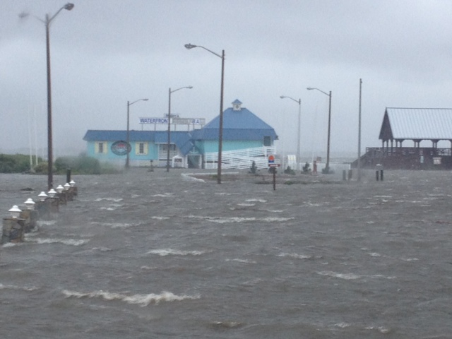
KILL DEVIL HILLS, NC -- Hurricane Arthur began moving offshore and away from North Carolina's Outer Banks early Friday after hitting the state's barrier islands overnight and causing flooding and tens of thousands of power outages. (Track the storm on our interactive hurricane map)
Arthur strengthened to a Category 2 storm with winds of 100 mph Thursday evening before passing over the southern end of the Outer Banks - a 200-mile string of narrow barrier islands with about 57,000 permanent residents. The islands are susceptible to high winds, rough seas and road-clogging sands, prompting an exodus that began Wednesday night.
By 9 a.m. Friday, Arthur had weakened to Category 1 hurricane with maximum sustained winds around 90 mph and additional weakening expected, the U.S. National Hurricane Center said.
The storm was moving northeast Friday morning after turning slightly west late Thursday, which increased the threat to mainland communities from flooding, tornadoes and intense winds.
But officials in some coastal areas in North Carolina reported few problems Friday morning.
Emerald Isle along the Bogue Banks posted on its website that the July 4th fireworks were still scheduled for Friday evening. The curfew also was lifted. Dare County officials said the northern end of the county, where Kill Devil Hills and Kitty Hawk, are located had reopened.
Hatteras Island on the southern end remained closed because of flooding on North Carolina Highway 12.
Jesse and Carol Wray could see outside their home in Salvo on North Carolina Highway 12 that the road was submerged under several feet of water Friday morning. The six-foot-tall lamppost at the end of their driveway was under water except for its top, and that was after the sound a quarter-mile away receded several feet since first light, said Jesse Wray, 68, a retired Norfolk, Virginia, firefighter.
"I'm surprised that it got this bad. There's all kind of debris floating around here. I know a lot of people who lost their houses around here" if they were built on the ground instead of elevated, Jesse Wray said. Wray's home is on pilings nine feet off the ground and avoided water inside.
About seven miles south on the island, Frank Folb, 70, said his brick home on a rise in Buxton suffered no damage. Tomato plants in his garden were twisted and broken, but "overall it's not bad," he said. "I've been losing electricity but I slept through the night pretty well."
Paul Wernock said water about 3 feet deep surrounded his Rodanthe, North Carolina, home but was receding early Friday. "We have one giant mess" from tree damage and debris, but no obvious structural damage to homes on his side street, he said.
As of Friday morning, more than 41,000 customers in North Carolina were without power, State Emergency Operations spokesman Rick Martinez said. Carteret County had 11,000 outages, the most of any county, he said.
Before the storm hit, tourism officials had expected 250,000 people to travel to the Outer Banks for the holiday weekend.
After passing over North Carolina early Friday, Hurricane Arthur was expected to weaken as it traveled northward and dump rain along the East Coast. The annual Boston Pops Fourth of July concert and fireworks show were held Thursday night just before of a heavy downpour from Arthur, while fireworks displays in New Jersey and Maine were postponed until later in the weekend.
As of 9 a.m. EDT Friday, Arthur was centered about 130 miles east of Norfolk, Virginia, and was moving northeast near 23 mph.
Arthur, the first named storm of the Atlantic season, prompted a hurricane warning from the southern North Carolina coast to the Virginia border. Tropical storm warnings were in effect for coastal areas as far north as Cape Cod, Massachusetts. Tropical storm watches and warnings were in effect for Nova Scotia in Canada.
Commanders at Seymour Johnson Air Force Base in Goldsboro, about 150 miles from the coast, sent four KC-135R Stratotankers and more than 50 F-15E Strike Eagles to another base near Dayton, Ohio, to avoid the risk of damage from high winds.


