AccuWeather


- Flood Warning
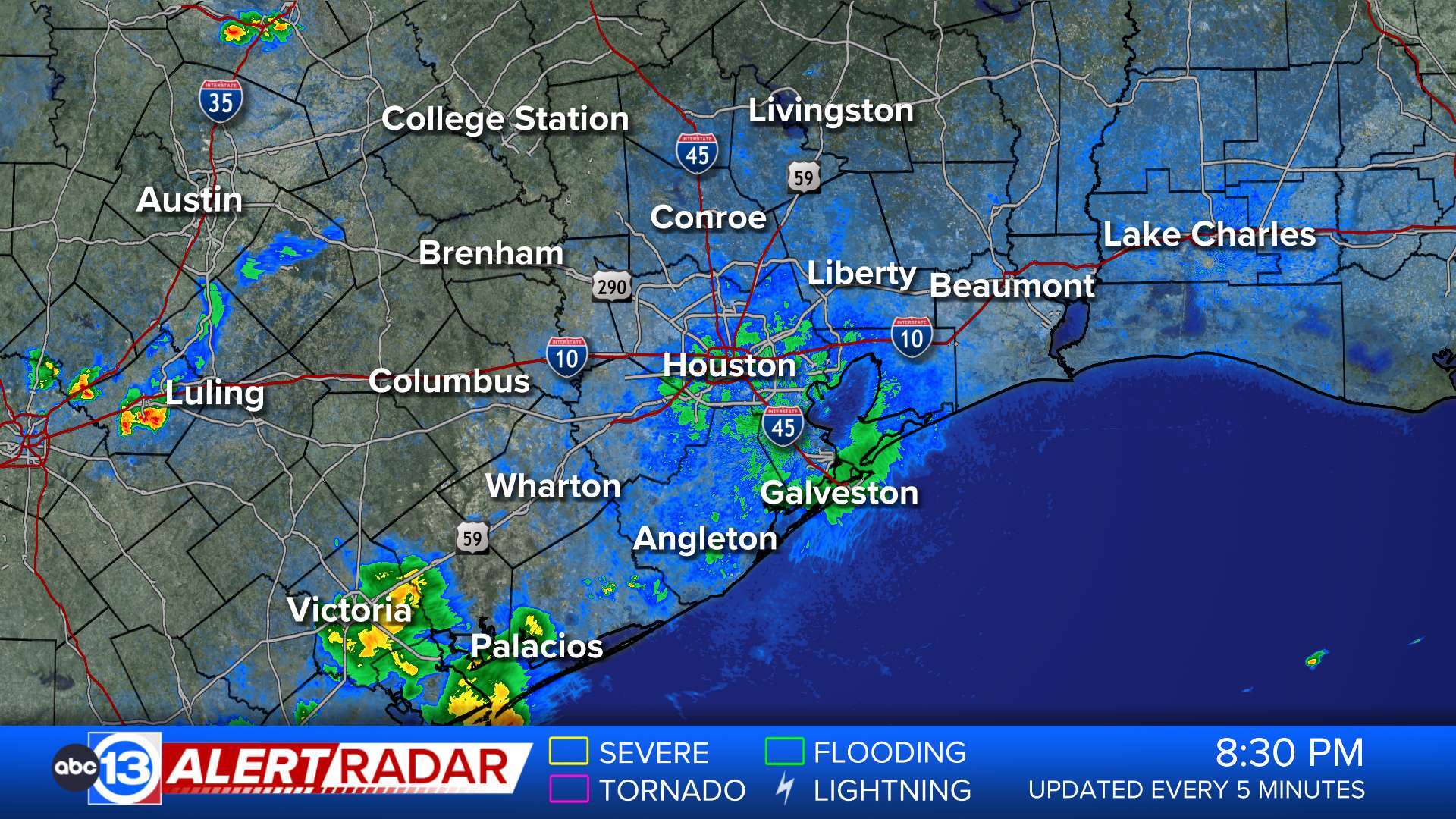
...The Flood Warning continues for the following rivers in Texas... Trinity River at Liberty affecting Liberty County. For the Trinity River...including Riverside, Romayor, Goodrich, Liberty, Moss Bluff...Major flooding is forecast. * WHAT...Major flooding is occurring and major flooding is forecast. * WHERE...Trinity River at Liberty. * WHEN...Until further notice. * IMPACTS...At 29.0 feet, Major lowland flooding begins as homes in several subdivisions above Liberty begin flooding. Extensive flooding over much of Liberty County can be expected with each incremental rise in the river. * ADDITIONAL DETAILS... - At 10:15 AM CDT Wednesday the stage was 29.2 feet. - Bankfull stage is 21.0 feet. - Recent Activity...The maximum river stage in the 24 hours ending at 10:15 AM CDT Wednesday was 29.2 feet. - Forecast...The river is expected to rise to a crest of 30.5 feet tomorrow evening. - Flood stage is 26.0 feet. - Flood History...This crest compares to a previous crest of 30.0 feet on 05/23/1990. - http://www.weather.gov/safety/floodMore
- Flood Warning
...The Flood Warning is extended for the following rivers in Texas... Trinity River near Romayor affecting Polk, Liberty and San Jacinto Counties. For the Trinity River...including Riverside, Romayor, Goodrich, Liberty, Moss Bluff...Major flooding is forecast. * WHAT...No flooding is currently forecast. * WHERE...Trinity River near Romayor. * WHEN...Until late this evening. * IMPACTS...At 40.0 feet, Minor lowland flooding begins as livestock and equipment near the river are endangered and communities in Liberty are threatened. * ADDITIONAL DETAILS... - At 10:30 AM CDT Wednesday the stage was 39.0 feet. - Bankfull stage is 30.0 feet. - Forecast...The river is expected to fall to 31.6 feet Monday morning. - Flood stage is 40.0 feet. - Flood History...This crest compares to a previous crest of 39.0 feet on 05/18/1958. - http://www.weather.gov/safety/floodMore
- Flood Warning
...The Flood Warning is extended for the following rivers in Texas... Trinity River near Goodrich affecting Polk, Liberty and San Jacinto Counties. For the Trinity River...including Riverside, Romayor, Goodrich, Liberty, Moss Bluff...Major flooding is forecast. * WHAT...Moderate flooding is occurring and moderate flooding is forecast. * WHERE...Trinity River near Goodrich. * WHEN...Until early Sunday morning. * IMPACTS...At 41.0 feet, Major lowland flooding begins as the slab elevation of homes on the right bank just below Lake Livingston is reached. * ADDITIONAL DETAILS... - At 9:45 AM CDT Wednesday the stage was 40.7 feet. - Bankfull stage is 36.0 feet. - Recent Activity...The maximum river stage in the 24 hours ending at 9:45 AM CDT Wednesday was 43.3 feet. - Forecast...The river is expected to fall below flood stage Saturday afternoon and continue falling to 30.3 feet Monday morning. - Flood stage is 36.0 feet. - Flood History...This crest compares to a previous crest of 40.5 feet on 03/30/2018. - http://www.weather.gov/safety/floodMore
- Flood Warning
...The Flood Warning continues for the following rivers in Texas... Trinity River near Moss Bluff affecting Chambers and Liberty Counties. For the Trinity River...including Riverside, Romayor, Goodrich, Liberty, Moss Bluff...Major flooding is forecast. * WHAT...Minor flooding is occurring and minor flooding is forecast. * WHERE...Trinity River near Moss Bluff. * WHEN...Until further notice. * IMPACTS...At 15.2 feet, Moderate lowland flooding begins in the vicinity of the gage. * ADDITIONAL DETAILS... - At 10:30 AM CDT Wednesday the stage was 13.8 feet. - Bankfull stage is 9.2 feet. - Recent Activity...The maximum river stage in the 24 hours ending at 10:30 AM CDT Wednesday was 13.8 feet. - Forecast...The river is expected to rise to 14.9 feet early Saturday afternoon. Additional rises are possible thereafter. - Flood stage is 12.2 feet. - Flood History...This crest compares to a previous crest of 14.9 feet on 06/04/2015. - http://www.weather.gov/safety/floodMore
- Flood Warning
...The Flood Warning is extended for the following rivers in Texas... East Fork San Jacinto near New Caney affecting Harris, Liberty and Montgomery Counties. For the East Fork San Jacinto River...including Cleveland, New Caney...Major flooding is forecast. * WHAT...Major flooding is occurring and major flooding is forecast. * WHERE...East Fork San Jacinto near New Caney. * WHEN...Until further notice. * IMPACTS...At 69.0 feet, Major lowland flooding begins as several homes become inundated. * ADDITIONAL DETAILS... - At 10:01 AM CDT Wednesday the stage was 69.9 feet. - Bankfull stage 54.5 feet. - Recent Activity...The maximum river stage in the 24 hours ending at 10:01 AM CDT Wednesday was 70.1 feet. - Forecast...The river is expected to fall to 58.0 feet Monday morning. - Flood stage is 58.0 feet. - Flood History...This crest compares to a previous crest of 69.6 feet on 05/29/2016. - http://www.weather.gov/safety/floodMore
- Flood Watch
* WHAT...Flooding caused by excessive rainfall continues to be possible. * WHERE...A portion of southeast Texas, including the following counties, Austin, Colorado and Waller. * WHEN...From this evening through Thursday evening. * IMPACTS...Excessive runoff may result in flooding of rivers, creeks, streams, and other low-lying and flood-prone locations. * ADDITIONAL DETAILS... - Another round of heavy rainfall and thunderstorms is expected tonight. Grounds are very saturated, so any additional rainfall will be slow to drain and could lead to street flooding and additional rises on rivers, creeks and streams. Rainfall totals of 2 to 4 inches can be expected north of I-10. Isolated higher amounts of 5 to 8 inches will be possible. - http://www.weather.gov/safety/floodMore
- Flood Watch
* WHAT...Flooding caused by excessive rainfall continues to be possible. * WHERE...A portion of southeast Texas, including the following areas, Brazos, Burleson, Grimes, Houston, Madison, Montgomery, Northern Liberty, Polk, San Jacinto, Southern Liberty, Trinity, Walker and Washington. * WHEN...From this evening through Thursday evening. * IMPACTS...Excessive runoff may result in flooding of rivers, creeks, streams, and other low-lying and flood-prone locations. * ADDITIONAL DETAILS... - Another round of heavy rainfall and thunderstorms is expected tonight. Grounds are very saturated, so any additional rainfall will be slow to drain and could lead to street flooding and additional rises on rivers, creeks and streams. Rainfall totals of 2 to 4 inches can be expected north of I-10. Isolated higher amounts of 5 to 8 inches will be possible. - http://www.weather.gov/safety/floodMore
- Coastal Flood Advisory
* WHAT...Minor coastal flooding. * WHERE...Coastal Aransas, Coastal Kleberg, Coastal Nueces, Coastal San Patricio, Coastal Refugio and Coastal Calhoun Counties. * WHEN...Until 7 PM CDT this evening. * IMPACTS...Flooding of lots, parks, and roads with only isolated road closures expected.More
- Coastal Flood Advisory
* WHAT...Dangerous rip currents and minor coastal flooding. * WHERE...Aransas Islands, Kleberg Islands, Nueces Islands and Calhoun Islands Counties. * WHEN...For the High Rip Current Risk, through Thursday morning. For the Coastal Flood Advisory, until 7 PM CDT this evening. * IMPACTS...Flooding of lots, parks, and roads with only isolated road closures expected. Rip currents can sweep even the most experienced swimmers away from shore into deeper water. These rip currents can become life-threatening to anyone entering the surf.More
- Rip Current Statement
* WHAT...Dangerous rip currents and minor coastal flooding. * WHERE...Aransas Islands, Kleberg Islands, Nueces Islands and Calhoun Islands Counties. * WHEN...For the High Rip Current Risk, through Thursday morning. For the Coastal Flood Advisory, until 7 PM CDT this evening. * IMPACTS...Flooding of lots, parks, and roads with only isolated road closures expected. Rip currents can sweep even the most experienced swimmers away from shore into deeper water. These rip currents can become life-threatening to anyone entering the surf.More